
File:WesternDesertBattle Area1941 en.svg

Size of this PNG preview of this SVG file: 800 × 374 pixels. Other resolutions: 320 × 149 pixels | 640 × 299 pixels | 1,024 × 478 pixels | 1,280 × 598 pixels | 2,560 × 1,195 pixels | 2,981 × 1,392 pixels.
Original file (SVG file, nominally 2,981 × 1,392 pixels, file size: 273 KB)
| This is a file from the Wikimedia Commons. Information from its description page there is shown below. Commons is a freely licensed media file repository. You can help. |
Summary
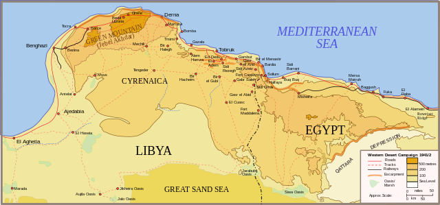
| Description | Egypt & Cyrenaica, Libya: Map of the Western Desert Campaign and its Operation Compass Battle Area 1941 |
| Date | |
| Source | Own work |
| Author | Stephen Kirrage talk - contribs |
| Other versions | Derivative works of this file: Afrikafeldzug 1941 42 de.svg |
Licensing
I, the copyright holder of this work, hereby publish it under the following licenses:

|
Permission is granted to copy, distribute and/or modify this document under the terms of the GNU Free Documentation License, Version 1.2 or any later version published by the Free Software Foundation; with no Invariant Sections, no Front-Cover Texts, and no Back-Cover Texts. A copy of the license is included in the section entitled GNU Free Documentation License. |
This file is licensed under the Creative Commons Attribution-Share Alike 3.0 Unported, 2.5 Generic, 2.0 Generic and 1.0 Generic license.
- You are free:
- to share – to copy, distribute and transmit the work
- to remix – to adapt the work
- Under the following conditions:
- attribution – You must give appropriate credit, provide a link to the license, and indicate if changes were made. You may do so in any reasonable manner, but not in any way that suggests the licensor endorses you or your use.
- share alike – If you remix, transform, or build upon the material, you must distribute your contributions under the same or compatible license as the original.
You may select the license of your choice.
File history
Click on a date/time to view the file as it appeared at that time.
| Date/Time | Thumbnail | Dimensions | User | Comment | |
|---|---|---|---|---|---|
| current | 12:47, 20 September 2023 | | 2,981 × 1,392 (273 KB) | Alyebard | File uploaded using svgtranslate tool (https://svgtranslate.toolforge.org/). Added translation for ca. |
| 18:59, 23 October 2008 |  | 2,981 × 1,392 (214 KB) | Kirrages | Removing some random (and tiny) place names that somehow got into the map - not even in the right place! | |
| 11:16, 2 November 2007 |  | 2,981 × 1,392 (216 KB) | Kirrages | Adjusting title | |
| 16:27, 17 October 2007 |  | 2,981 × 1,392 (211 KB) | Kirrages | ||
| 09:39, 15 October 2007 |  | 2,981 × 1,392 (206 KB) | Kirrages | Making larger | |
| 09:35, 15 October 2007 |  | 2,104 × 982 (206 KB) | Kirrages | ||
| 23:52, 14 October 2007 |  | 1,123 × 524 (206 KB) | Kirrages | ||
| 23:46, 14 October 2007 |  | 1,123 × 524 (205 KB) | Kirrages | ||
| 23:45, 14 October 2007 |  | 1,123 × 524 (205 KB) | Kirrages | ||
| 23:36, 14 October 2007 |  | 1,123 × 524 (205 KB) | Kirrages |
File usage
The following pages on the English Wikipedia use this file (pages on other projects are not listed):
- 63rd Infantry Division "Cirene"
- 64th Infantry Division "Catanzaro"
- Battle of Bardia
- Battle of El Agheila
- Battle of Gazala
- Battle of Sidi Barrani
- British Army during the Second World War
- Egypt in World War II
- Egypt–Libya relations
- Erwin Rommel
- First Battle of El Alamein
- HMS Terror (I03)
- Italian invasion of Egypt
- Long Range Desert Group
- Operation Compass
- Second Battle of El Alamein
- US Naval Bases North Africa
- XX Army Corps (Italy)
- User:Gunbirddriver/Images
- User talk:Kirrages
Global file usage
The following other wikis use this file:
- Usage on ar.wikipedia.org
- Usage on arz.wikipedia.org
- Usage on azb.wikipedia.org
- Usage on bg.wikipedia.org
- Usage on ca.wikipedia.org
- Usage on da.wikipedia.org
- Usage on de.wikipedia.org
- Usage on et.wikipedia.org
- Usage on fa.wikipedia.org
- Usage on fi.wikipedia.org
- Usage on fr.wikipedia.org
- Usage on he.wikipedia.org
- Usage on hr.wikipedia.org
- Usage on hu.wikipedia.org
- Usage on id.wikipedia.org
- Usage on it.wikipedia.org
- Usage on ja.wikipedia.org
View more global usage of this file.