
File:Weimar Republic states map.svg

Size of this PNG preview of this SVG file: 715 × 599 pixels. Other resolutions: 286 × 240 pixels | 573 × 480 pixels | 916 × 768 pixels | 1,222 × 1,024 pixels | 2,444 × 2,048 pixels | 976 × 818 pixels.
Original file (SVG file, nominally 976 × 818 pixels, file size: 949 KB)
| This is a file from the Wikimedia Commons. Information from its description page there is shown below. Commons is a freely licensed media file repository. You can help. |
Summary
| Description |
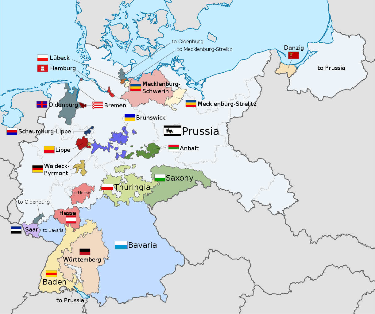
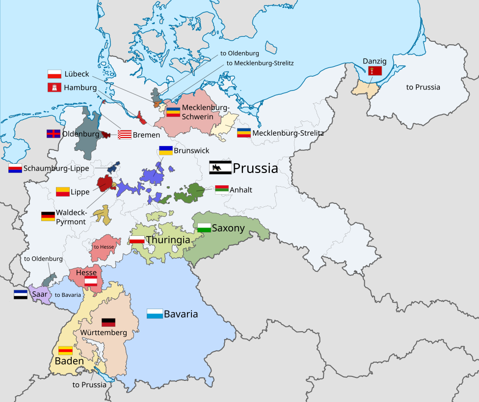
English: A map of the states of the Weimar Republic, showing their location, flags and names in English. |
| Date | |
| Source |
This file was derived from: Weimar Republic blank map.svg: This vector image includes elements that have been taken or adapted from this file: This vector image includes elements that have been taken or adapted from this file: This vector image includes elements that have been taken or adapted from this file: This vector image includes elements that have been taken or adapted from this file: This vector image includes elements that have been taken or adapted from this file: This vector image includes elements that have been taken or adapted from this file: This vector image includes elements that have been taken or adapted from this file: This vector image includes elements that have been taken or adapted from this file: This vector image includes elements that have been taken or adapted from this file: This vector image includes elements that have been taken or adapted from this file: This vector image includes elements that have been taken or adapted from this file: This vector image includes elements that have been taken or adapted from this file: This vector image includes elements that have been taken or adapted from this file: This vector image includes elements that have been taken or adapted from this file: This vector image includes elements that have been taken or adapted from this file: This vector image includes elements that have been taken or adapted from this file: |
| Author |
|
| Other versions |
|
| SVG development | This flag was created with Inkscape. This flag uses embedded text that can be easily translated using a text editor. |


.svg)


.svg)
.svg)
.svg)
.svg)
Licensing
I, the copyright holder of this work, hereby publish it under the following license:
This file is licensed under the Creative Commons Attribution-Share Alike 3.0 Unported license.
- You are free:
- to share – to copy, distribute and transmit the work
- to remix – to adapt the work
- Under the following conditions:
- attribution – You must give appropriate credit, provide a link to the license, and indicate if changes were made. You may do so in any reasonable manner, but not in any way that suggests the licensor endorses you or your use.
- share alike – If you remix, transform, or build upon the material, you must distribute your contributions under the same or compatible license as the original.
Code for clickable map

File history
Click on a date/time to view the file as it appeared at that time.
| Date/Time | Thumbnail | Dimensions | User | Comment | |
|---|---|---|---|---|---|
| current | 22:22, 17 December 2021 | | 976 × 818 (949 KB) | Alphathon | Corrections to Anhalt and Brunswick |
| 03:28, 5 November 2015 |  | 976 × 818 (981 KB) | Alphathon | {{Information |Description={{en|A map of the states of the en:Weimar Republic, showing their location, flags and names in English.}}{{Valid SVG}} |Source={{Derived from|File:Weimar Republic blank map.svg|display=50}} {{AttribSVG|Flag of Prussia (... |
File usage
The following pages on the English Wikipedia use this file (pages on other projects are not listed):
- Gleichschaltung
- Law on the Reconstruction of the Reich
- Nazi Party election results
- Provisional Law and Second Law on the Coordination of the States with the Reich
- Prussia
- Reichsrat (Germany)
- Reichsstatthalter
- States of Germany
- States of the Weimar Republic
- Weimar Republic
- User:Falcaorib
- Template:Weimar Republic States
Global file usage
The following other wikis use this file:
- Usage on ar.wikipedia.org
- Usage on ast.wikipedia.org
- Usage on ca.wikipedia.org
- Usage on fa.wikipedia.org
- Usage on fy.wikipedia.org
- Usage on gd.wikipedia.org
- Usage on hy.wikipedia.org
- Usage on id.wikipedia.org
- Usage on it.wikipedia.org
- Usage on kk.wikipedia.org
- Usage on lt.wikipedia.org
- Usage on ms.wikipedia.org
- Usage on pt.wikipedia.org
- Usage on simple.wikipedia.org
- Usage on tr.wikipedia.org
- Usage on ur.wikipedia.org
- Usage on zh.wikipedia.org