
File:Wax Lake Delta.jpg
No higher resolution available.
Wax_Lake_Delta.jpg (292 × 256 pixels, file size: 84 KB, MIME type: image/jpeg)
| This is a file from the Wikimedia Commons. Information from its description page there is shown below. Commons is a freely licensed media file repository. You can help. |
| Description |
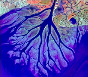
English: The Wax Lake Delta was formed by the deposition of sediment from a shipping canal off of the Atchafalaya River. The channel was routed through Wax Lake, which quickly filled with sediment. After Wax Lake filled, the sediment from the canal deposited offshore and created the delta. |
|||
| Date | ||||
| Source | National Center for Earth-surface Dynamics; http://www.nced.umn.edu/printview/Field_Site_Wax_Lake_Delta | |||
| Author | National Center for Earth-surface Dynamics | |||
| Permission (Reusing this file) |
|

| Camera location | | View this and other nearby images on: OpenStreetMap |
|---|
File history
Click on a date/time to view the file as it appeared at that time.
| Date/Time | Thumbnail | Dimensions | User | Comment | |
|---|---|---|---|---|---|
| current | 21:02, 19 December 2008 | | 292 × 256 (84 KB) | Awickert | {{Information |Description={{en|1=The Wax Lake Delta was formed by the deposition of sediment from a shipping canal off of the Atchafalaya River. The channel was routed through Wax Lake, which quickly filled with sediment. After Wax Lake filled, the sedim |
File usage
The following pages on the English Wikipedia use this file (pages on other projects are not listed):
Global file usage
The following other wikis use this file:
- Usage on de.wikipedia.org
- Usage on es.wikipedia.org
- Usage on fr.wikipedia.org
- Usage on www.wikidata.org