
File:WarszawaDocelowyUkladDrog.svg

Size of this PNG preview of this SVG file: 743 × 599 pixels. Other resolutions: 298 × 240 pixels | 595 × 480 pixels | 952 × 768 pixels | 1,270 × 1,024 pixels | 2,539 × 2,048 pixels | 1,199 × 967 pixels.
Original file (SVG file, nominally 1,199 × 967 pixels, file size: 91 KB)
| This is a file from the Wikimedia Commons. Information from its description page there is shown below. Commons is a freely licensed media file repository. You can help. |
| Description |
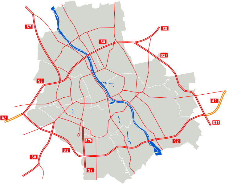
Polski: Docelowy układ dróg w Warszawie.
English: Map of the planned motorways in Warsaw.
Main roads
Deutsch: Straßennetz in Warschau, geplannter Endzustand
Hauptstraßen |
| Date | (UTC) |
| Source | |
| Author |
|
| This is a retouched picture, which means that it has been digitally altered from its original version. Modifications: Added planned motorways. The original can be viewed here: Warszawa outline with districts v2.svg:
|
This file is licensed under the Creative Commons Attribution 3.0 Unported license.
- You are free:
- to share – to copy, distribute and transmit the work
- to remix – to adapt the work
- Under the following conditions:
- attribution – You must give appropriate credit, provide a link to the license, and indicate if changes were made. You may do so in any reasonable manner, but not in any way that suggests the licensor endorses you or your use.
Original upload log
This image is a derivative work of the following images:
- File:Warszawa_outline_with_districts_v2.svg licensed with Cc-by-2.5, Cc-by-sa-3.0-migrated, GFDL
- 2007-03-06T23:15:36Z Mfloryan 1065x1063 (63886 Bytes)
- 2007-03-06T22:59:54Z Mfloryan 1065x1063 (62195 Bytes) {{Information |Description={{pl|Mapa warszawy z zaznaczonym podziałem administracyjnym na tle barw miasta}}{{en|An outline of Warsaw and its administrative divisions}} |Source=own work {{Inkscape}} |Date=2007-03-05 |Author=[
Uploaded with derivativeFX
File history
Click on a date/time to view the file as it appeared at that time.
| Date/Time | Thumbnail | Dimensions | User | Comment | |
|---|---|---|---|---|---|
| current | 09:04, 13 February 2010 | | 1,199 × 967 (91 KB) | Sliwers | Removed expressway to Magdalenka |
| 20:38, 26 November 2009 |  | 1,199 × 967 (92 KB) | Sliwers | Improved S8 | |
| 16:52, 22 November 2009 |  | 1,199 × 967 (91 KB) | Sliwers | Red roads | |
| 20:32, 2 September 2009 |  | 1,199 × 967 (86 KB) | Sliwers | Fixed lines thickness | |
| 18:47, 2 September 2009 |  | 1,199 × 967 (86 KB) | Sliwers | {{Information |Description={{pl|Docelowy układ dróg klasy A, S i GP w Warszawie.}} {{en|Map of the planned motorways in Warsaw.}} |Source=*File:Warszawa_outline_with_districts_v2.svg |Date=2009-09-02 18:46 (UTC) |Author=*[[:File:Warszawa_outline_w |
File usage
The following pages on the English Wikipedia use this file (pages on other projects are not listed):
Global file usage
The following other wikis use this file: