
File:Wales relief location map.jpg
Size of this preview: 502 × 600 pixels. Other resolutions: 201 × 240 pixels | 402 × 480 pixels | 643 × 768 pixels | 857 × 1,024 pixels | 2,000 × 2,390 pixels.
Original file (2,000 × 2,390 pixels, file size: 742 KB, MIME type: image/jpeg)
| This is a file from the Wikimedia Commons. Information from its description page there is shown below. Commons is a freely licensed media file repository. You can help. |
| Description |
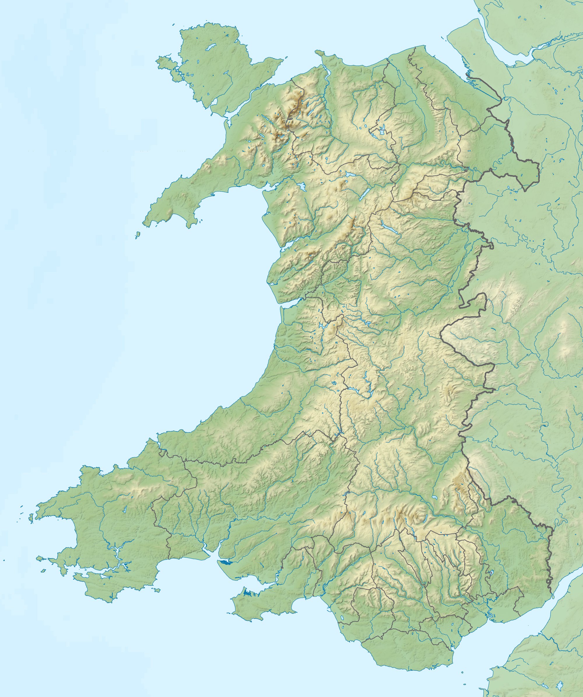
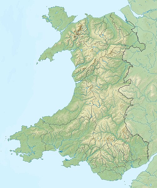
Relief map of Wales, UK. Equirectangular map projection on WGS 84 datum, with N/S stretched 170%
|
| Date | |
| Source |
|
| Author | Nilfanion, created using Ordnance Survey data |
| Permission (Reusing this file) |
This file is licensed under the Creative Commons Attribution-Share Alike 3.0 Unported license. Attribution: Contains Ordnance Survey data © Crown copyright and database right
|
| Other versions | File:Wales location map.svg - Blank map |
File history
Click on a date/time to view the file as it appeared at that time.
| Date/Time | Thumbnail | Dimensions | User | Comment | |
|---|---|---|---|---|---|
| current | 11:53, 9 December 2011 | | 2,000 × 2,390 (742 KB) | Nilfanion | {{Information |Description=Relief map of Wales, UK. Equirectangular map projection on WGS 84 datum, with N/S stretched 170% *West: 5.5W *East: 2.5W *North: 53.5N *South: 51.3N |Source=Ordnance Survey [https://www.ordnan |
File usage
More than 100 pages use this file. The following list shows the first 100 pages that use this file only. A full list is available.
- 1990 Bishop's Castle earthquake
- 2010 Ryder Cup
- Afon Cych
- Afon Hydfer
- Afon Lledr
- Afon Llyfni
- Afon Porth-llwyd
- Afon Roe
- Afon Tryweryn
- Afon Wyre
- Alabum
- Aran Fawddwy
- Atlantic College Lifeboat Station
- Bala Lake
- Bangor Mountain
- Barclodiad y Gawres
- Barry Dock Lifeboat Station
- Battle of St Fagans
- Bedd Arthur
- Berwyn range
- Black Mountain (hill)
- Bodedern
- Bontnewydd Palaeolithic site
- Bremia (fort)
- Broad Water
- Burrium
- Cadair Berwyn
- Cadw
- Caerfanell
- Caerleon Roman Fortress and Baths
- Cantref Reservoir
- Capital of Wales
- Cardiff
- Cardiff United Synagogue
- Carn Fadryn
- Carreg Coetan Arthur
- Constitution Hill, Aberystwyth
- Crai Reservoir
- Craig y Llyn
- Cwm Dyli
- Dinefwr Park National Nature Reserve
- Dinorwig Power Station
- Elan Valley Reservoirs
- Epson Grand Prix of Europe
- Ffynnon Lloer
- Foel Wen South Top
- Gallt yr Ogof
- Garth Hill
- Great Orme
- Horton and Port Eynon Lifeboat Station
- Isca Augusta
- List of Cadw properties
- Llanerchaeron
- Llechog
- Llyn Alwen
- Llyn Cwm-y-ffynnon
- Llyn Padarn
- Mathrafal
- Merthyr Synagogue
- Moel Druman
- Moel Famau
- Moel Fferna
- Moel Penamnen
- Moel Sych
- Moel y Gamelin
- Moelfre Isaf
- Neath Abbey
- Newport, Wales
- Newton House, Llandeilo
- Park House, Cardiff
- Penarth Lifeboat Station
- Penmynydd
- Pistyll Rhaeadr
- Pistyll y Llyn
- Plas Newydd (Anglesey)
- Port Talbot
- Port Talbot Lifeboat Station
- Porthcawl Lifeboat Station
- Rheidol Power Station
- River Loughor
- River Teifi
- Rowland Laugharne
- Royal Porthcawl Golf Club
- Second English Civil War
- Siege of Pembroke
- St David's Head
- Strata Florida Abbey
- Strata Marcella
- Swansea
- Tenby Lifeboat Station
- The Kymin
- The Mumbles Lifeboat Station
- Thomas Mytton
- Twmbarlwm
- Valle Crucis Abbey
- Wales Challenge
- Wales Open
- Wales Seniors Open
- Welsh Golf Classic
- Ysbyty Ifan
View more links to this file.
Global file usage
The following other wikis use this file:
- Usage on ar.wikipedia.org
- Usage on ast.wikipedia.org
- Usage on az.wikipedia.org
- Usage on ba.wikipedia.org
- Usage on bg.wikipedia.org
- Ланголен
- Кардиф
- Суонзи
- Брекън
- Нюпорт
- Мърдър Тидфил (град)
- Денби
- Тремадог
- Колуин Бей
- Уитфорд
- Бангор (Уелс)
- Сейнт Дейвидс
- Ъск
- Престатин
- Рил
- Коруен
- Карог
- Ридлан
- Ридин
- Сейнт Асаф
- Моулд
- Багилт
- Бъкли
- Ъстрад Мънах
- Кайруис
- Конас Кий
- Юлоу
- Флинт (Уелс)
- Хардън
- Бротън
- Хоулиуел
- Куинсфери
- Солтни
- Шотън
- Чърк
- Рексъм (град)
- Амлух
- Биумарис
- Бенлех
- Хоулихед
- Лангевни
- Менай Бридж
- Абергеле
- Конуи (град)
View more global usage of this file.