
File:Volcanic zones of Iceland.svg

Size of this PNG preview of this SVG file: 726 × 550 pixels. Other resolutions: 317 × 240 pixels | 634 × 480 pixels | 1,014 × 768 pixels | 1,280 × 970 pixels | 2,560 × 1,939 pixels.
Original file (SVG file, nominally 726 × 550 pixels, file size: 162 KB)
| This is a file from the Wikimedia Commons. Information from its description page there is shown below. Commons is a freely licensed media file repository. You can help. |
Summary
| Description |
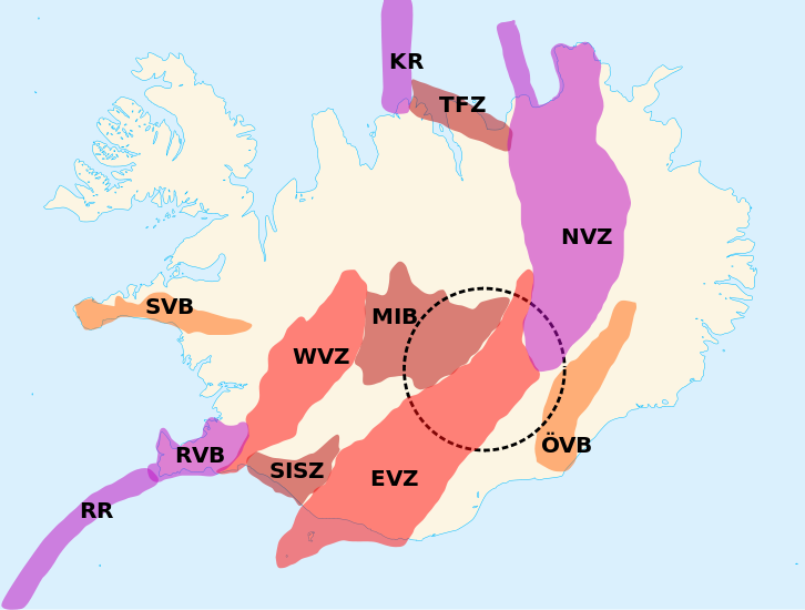
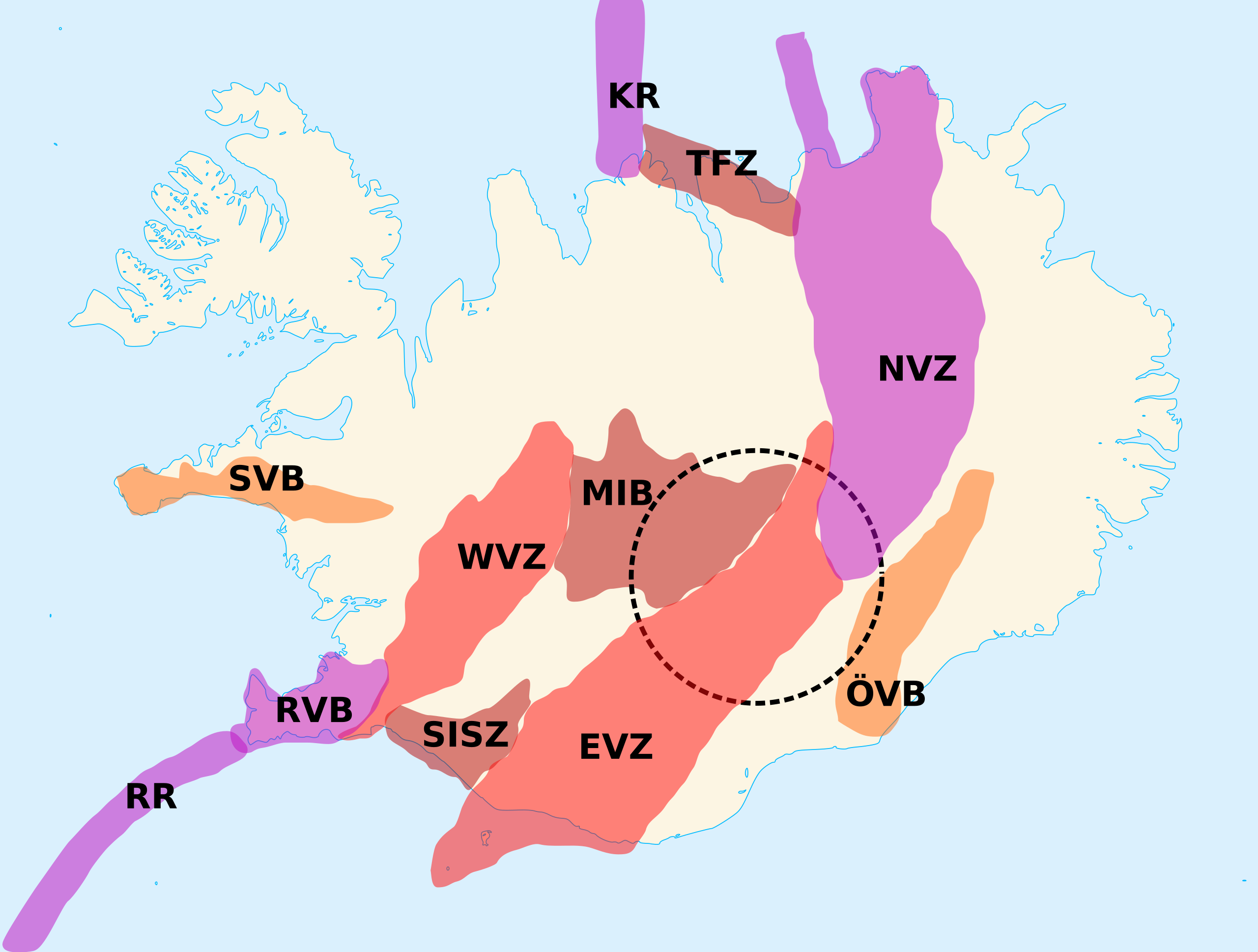
English: Delimitations of the eleven volcanic zones of Iceland. The dotted circle is the position of the hypothetical Iceland hotspot. Français : Délimitations des onze zones volcaniques d’Islande. Le cercle pointillé indique la position de l’hypothétique point chaud d’Islande. KR: Kolbeinsey Ridge.
NVZ: North Volcanic Zone.
RVB: Reykjanes Volcanic Belt.
RR: Reykjanes Ridge.
TFZ: Tjörnes Fracture Zone.
MIB: Mid-Iceland Belt.
SISZ: South Iceland Seismic Zone.
WVZ: West Volcanic Zone.
EVZ: East Volcanic Zone.
ÖVB: Öræfi Volcanic Belt. |
| Date | |
| Source | Own work made with inkscape from Image:Blank map of Iceland.svg and [1] |
| Author | Lanredec |
Licensing
I, the copyright holder of this work, hereby publish it under the following license:
This file is licensed under the Creative Commons Attribution-Share Alike 3.0 Unported license.
- You are free:
- to share – to copy, distribute and transmit the work
- to remix – to adapt the work
- Under the following conditions:
- attribution – You must give appropriate credit, provide a link to the license, and indicate if changes were made. You may do so in any reasonable manner, but not in any way that suggests the licensor endorses you or your use.
- share alike – If you remix, transform, or build upon the material, you must distribute your contributions under the same or compatible license as the original.
File history
Click on a date/time to view the file as it appeared at that time.
| Date/Time | Thumbnail | Dimensions | User | Comment | |
|---|---|---|---|---|---|
| current | 11:09, 8 October 2011 | | 726 × 550 (162 KB) | Ciaurlec | Filled areas, differenciated colours according to type of zone |
| 10:40, 18 June 2011 |  | 726 × 550 (201 KB) | Lanredec |
File usage
The following pages on the English Wikipedia use this file (pages on other projects are not listed):
Global file usage
The following other wikis use this file:
- Usage on da.wikipedia.org
- Usage on es.wikipedia.org
- Usage on fr.wikipedia.org
- Torfajökull
- Parc national du Vatnajökull
- Point chaud d'Islande
- Région volcanique d'Islande
- Ceinture volcanique de Reykjanes
- Zone de fracture de Tjörnes
- Zone volcanique Ouest
- Ceinture médio-islandaise
- Zone volcanique Est
- Zone volcanique Nord
- Ceinture volcanique d'Öræfi
- Ceinture volcanique de Snæfellsnes
- Usage on hu.wikipedia.org
- Usage on id.wikipedia.org
- Usage on pl.wikipedia.org
- Usage on pt.wikipedia.org
- Usage on zh.wikipedia.org