
File:Vimy Ridge map-April 9-April 12.jpg
Original file (1,472 × 943 pixels, file size: 389 KB, MIME type: image/jpeg)
| This is a file from the Wikimedia Commons. Information from its description page there is shown below. Commons is a freely licensed media file repository. You can help. |
Summary
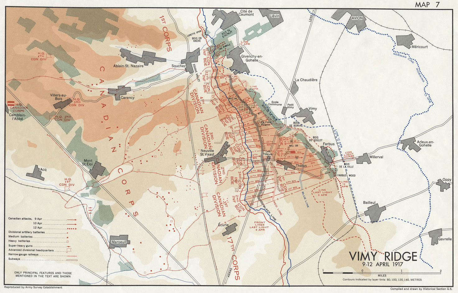
| Description | 'Map 7 Vimy Ridge' from Nicholson text, Compiled and drawn by Historical Section of the General Staff, Department of National Defence |
| Source | Canadian War Museum file CWM19980056-280 & Nicholson, G. W. L. 1962. Official History of the Canadian Army in the First World War: Canadian Expeditionary Force 1914-1919. Queens Printer and Controller of Stationary, Ottawa, Canada. |
| Author | Historical Section of the General Staff, Department of National Defence |
| Permission (Reusing this file) |
Library and Archives Canada, http://www.collectionscanada.gc.ca/notices/016-200-e.html |
Licensing
This Canadian work is in the public domain in Canada because its copyright has expired due to one of the following:
it was not subject to Crown copyright, and
|
 |
Original upload log
The original description page is/was here. All following user names refer to en.wikipedia.
- 19:27, January 5, 2008 Labattblueboy 1,472×943 (389 KB) {{Information |Description= 'Map 7 Vimy Ridge' Compiled and drawn by Historical Section of the General Staff, Department of National Defence |Source= Canadian War Museum file CWM19980056-280 & Nicholson, G. W. L. 1962. Official History of the Canadian Arm
File history
Click on a date/time to view the file as it appeared at that time.
| Date/Time | Thumbnail | Dimensions | User | Comment | |
|---|---|---|---|---|---|
| current | 20:54, 5 January 2008 | | 1,472 × 943 (389 KB) | Labattblueboy | {{Information |Description= 'Map 7 Vimy Ridge' from Nicholson text, Compiled and drawn by Historical Section of the General Staff, Department of National Defence |Source= Canadian War Museum file CWM19980056-280 & Nicholson, G. W. L. 1962. Official Histor |
File usage
Global file usage
The following other wikis use this file:
- Usage on fr.wikipedia.org
- Usage on it.wikipedia.org