
File:View across Botany Bay from Inscription Point.jpg

Size of this preview: 800 × 600 pixels. Other resolutions: 320 × 240 pixels | 640 × 480 pixels | 1,024 × 768 pixels | 1,280 × 960 pixels | 2,560 × 1,920 pixels | 3,264 × 2,448 pixels.
Original file (3,264 × 2,448 pixels, file size: 2.94 MB, MIME type: image/jpeg)
| This is a file from the Wikimedia Commons. Information from its description page there is shown below. Commons is a freely licensed media file repository. You can help. |
Summary
| Description |
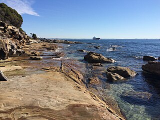
English: In this image, taken from Inscription Point on the South Head region of Kamay Botany Bay National Park, we look across Botany Bay, looking northwest in the direction of an outbound cargo ship, presumably originating from Port Botany. In the foreground, weathered and eroded rocks sit idle in the water and are constantly splashed by the occasional wave. |
| Date | |
| Source | Own work |
| Author | Philip Terry Graham |
| Camera location | | View this and other nearby images on: OpenStreetMap |
|---|
Assessment
|

Licensing
I, the copyright holder of this work, hereby publish it under the following license:
This file is licensed under the Creative Commons Attribution 2.0 Generic license.
- You are free:
- to share – to copy, distribute and transmit the work
- to remix – to adapt the work
- Under the following conditions:
- attribution – You must give appropriate credit, provide a link to the license, and indicate if changes were made. You may do so in any reasonable manner, but not in any way that suggests the licensor endorses you or your use.
File history
Click on a date/time to view the file as it appeared at that time.
| Date/Time | Thumbnail | Dimensions | User | Comment | |
|---|---|---|---|---|---|
| current | 19:28, 30 November 2015 | | 3,264 × 2,448 (2.94 MB) | PhilipTerryGraham | User created page with UploadWizard |
File usage
The following pages on the English Wikipedia use this file (pages on other projects are not listed):
Global file usage
The following other wikis use this file:
- Usage on es.wikipedia.org
- Usage on fa.wikipedia.org
- Usage on ja.wikipedia.org
- Usage on ur.wikipedia.org