
File:Verwantschapslanden.png

Size of this preview: 800 × 352 pixels. Other resolutions: 320 × 141 pixels | 640 × 282 pixels | 1,427 × 628 pixels.
Original file (1,427 × 628 pixels, file size: 60 KB, MIME type: image/png)
| This is a file from the Wikimedia Commons. Information from its description page there is shown below. Commons is a freely licensed media file repository. You can help. |

|
This historical map image could be re-created using vector graphics as an SVG file. This has several advantages; see Commons:Media for cleanup for more information. If an SVG form of this image is available, please upload it and afterwards replace this template with
{{vector version available|new image name}}.
It is recommended to name the SVG file “Verwantschapslanden.svg”—then the template Vector version available (or Vva) does not need the new image name parameter. |
| Description |
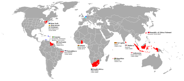
English: Countries and subnational entities (in the case of Brazil and the United States), that were significantly colonized by the Netherlands. These countries are sometimes known as "verwantschapslanden" (kindred countries) in Dutch. Nederlands: Verwantschapslanden van Nederland. |
| Date | (UTC) |
| Source | |
| Author |
|
I, the copyright holder of this work, hereby publish it under the following licenses:
This file is licensed under the Creative Commons Attribution-Share Alike 2.5 Generic, 2.0 Generic and 1.0 Generic license.
- You are free:
- to share – to copy, distribute and transmit the work
- to remix – to adapt the work
- Under the following conditions:
- attribution – You must give appropriate credit, provide a link to the license, and indicate if changes were made. You may do so in any reasonable manner, but not in any way that suggests the licensor endorses you or your use.
- share alike – If you remix, transform, or build upon the material, you must distribute your contributions under the same or compatible license as the original.
| This file is licensed under the Creative Commons Attribution-Share Alike 3.0 Unported license. | ||
| ||
| This licensing tag was added to this file as part of the GFDL licensing update. |

|
Permission is granted to copy, distribute and/or modify this document under the terms of the GNU Free Documentation License, Version 1.2 or any later version published by the Free Software Foundation; with no Invariant Sections, no Front-Cover Texts, and no Back-Cover Texts. A copy of the license is included in the section entitled GNU Free Documentation License. |
You may select the license of your choice.
Original upload log
This image is a derivative work of the following images:
- File:BlankMap-World-USA.png licensed with Cc-by-sa-2.5,2.0,1.0, Cc-by-sa-3.0-migrated, GFDL
- 2008-07-05T07:34:49Z Roke 1427x628 (52028 Bytes)
- 2007-01-24T10:05:30Z Roke 1427x628 (30177 Bytes)
- 2007-01-24T10:02:28Z Roke 1427x628 (30134 Bytes)
- 2007-01-24T09:58:23Z Roke 1427x628 (30134 Bytes)
- 2006-05-11T17:12:22Z Roke 1393x628 (49510 Bytes) minor fix join island to alaska
- 2006-03-25T11:35:28Z Roke 1393x628 (49508 Bytes) Map based on [[:Image:BlankMap-World-v5.png]] with US states marked - for comparisons between US states and other countries. [[Category:Blank world maps]]
Uploaded with derivativeFX
File history
Click on a date/time to view the file as it appeared at that time.
| Date/Time | Thumbnail | Dimensions | User | Comment | |
|---|---|---|---|---|---|
| current | 00:09, 14 February 2011 | | 1,427 × 628 (60 KB) | Fentener van Vlissingen | +Malacca (Malaysian state) |
| 22:30, 3 February 2011 |  | 1,427 × 628 (58 KB) | Fentener van Vlissingen | {{Information |Description={{nl|Verwantschapslanden van Nederland.}} |Source=*File:BlankMap-World-USA.png |Date=2011-02-03 22:28 (UTC) |Author=*File:BlankMap-World-USA.png: Roke *derivative work: ~~~ |Permission= |other_versions= |
File usage
The following pages on the English Wikipedia use this file (pages on other projects are not listed):
Global file usage
The following other wikis use this file:
- Usage on af.wikipedia.org
- Usage on eo.wikipedia.org
- Usage on gl.wikipedia.org
- Usage on sl.wikipedia.org
- Usage on vi.wikipedia.org
- Usage on zh.wikipedia.org