
File:Verbreitungskarte Judensau.png
Size of this preview: 560 × 600 pixels. Other resolutions: 224 × 240 pixels | 448 × 480 pixels | 717 × 768 pixels | 956 × 1,024 pixels | 1,401 × 1,500 pixels.
Original file (1,401 × 1,500 pixels, file size: 664 KB, MIME type: image/png)
| This is a file from the Wikimedia Commons. Information from its description page there is shown below. Commons is a freely licensed media file repository. You can help. |
Summary
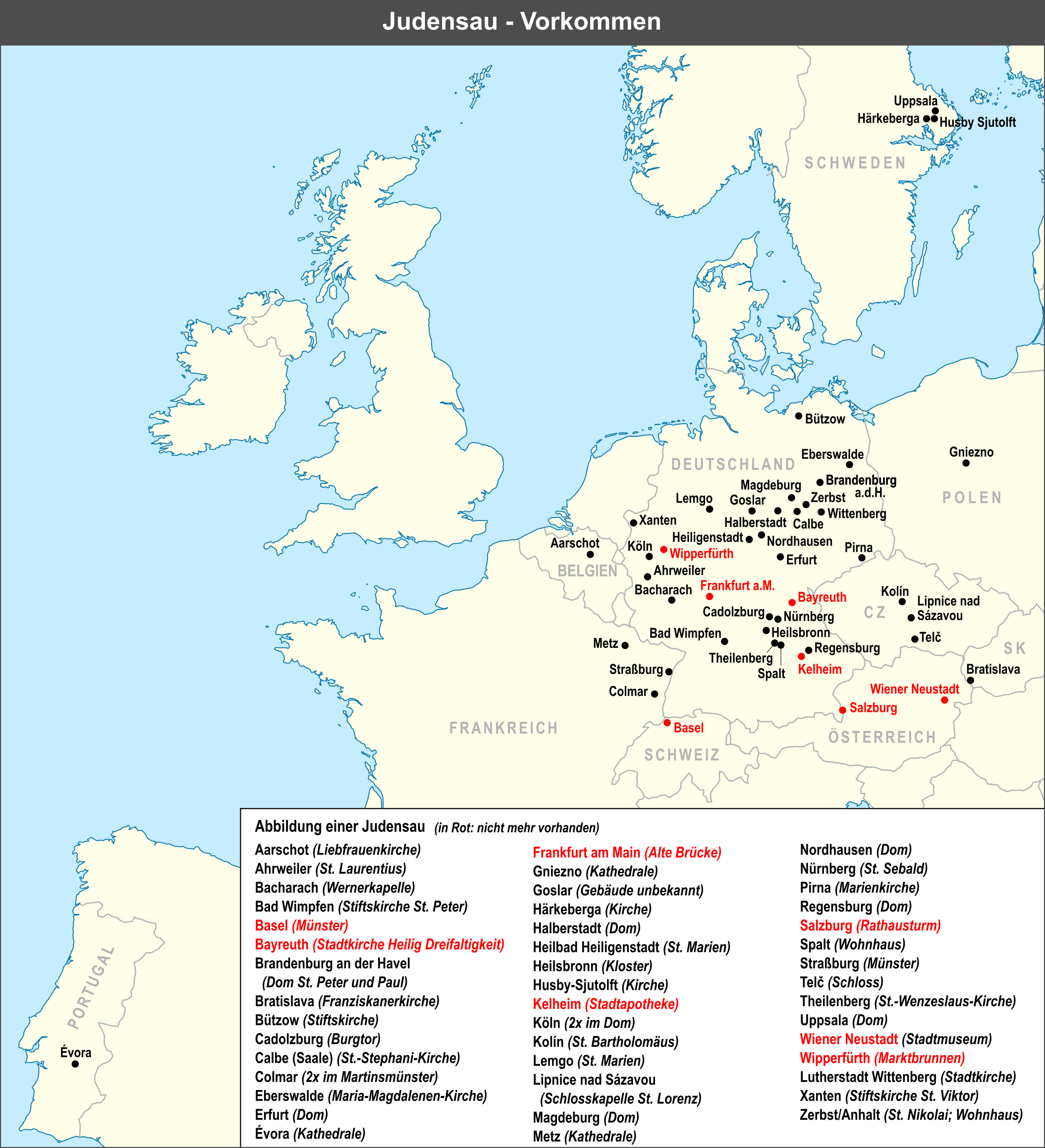
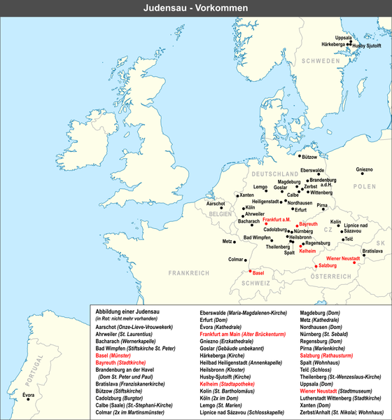
| Description | Vorkommen der Judensau |
| Date | |
| Source | Own work, used Europe laea location map.svg created by Alexrk2 |
| Author | Lencer |

|
This map has been made or improved in the German Kartenwerkstatt (Map Lab). You can propose maps to improve as well.
|
Licensing
The map has been created with the Generic Mapping Tools: https://www.generic-mapping-tools.org/ using one or more of these public-domain datasets for the relief:
|

|
Permission is granted to copy, distribute and/or modify this document under the terms of the GNU Free Documentation License, Version 1.2 or any later version published by the Free Software Foundation; with no Invariant Sections, no Front-Cover Texts, and no Back-Cover Texts. A copy of the license is included in the section entitled GNU Free Documentation License. |
| This file is licensed under the Creative Commons Attribution-Share Alike 3.0 Unported license. | ||
| ||
| This licensing tag was added to this file as part of the GFDL licensing update. |
File history
Click on a date/time to view the file as it appeared at that time.
| Date/Time | Thumbnail | Dimensions | User | Comment | |
|---|---|---|---|---|---|
| current | 16:45, 15 July 2022 | | 1,401 × 1,500 (664 KB) | Lencer | small fix |
| 07:30, 29 June 2022 |  | 1,401 × 1,500 (660 KB) | Lencer | small fixes | |
| 08:47, 28 June 2022 |  | 1,401 × 1,500 (661 KB) | Lencer | neue, vollständig überarbeitete, korrigierte und ergänzte Version | |
| 08:54, 15 June 2022 |  | 2,374 × 2,788 (1.28 MB) | Lencer | Freising in Karte gelöscht | |
| 08:49, 15 June 2022 |  | 2,374 × 2,788 (1.28 MB) | Lencer | typo | |
| 08:48, 15 June 2022 |  | 2,000 × 2,349 (1.28 MB) | Lencer | Lage der Orte korrigiert | |
| 08:35, 15 June 2022 |  | 2,000 × 2,349 (1.28 MB) | Lencer | Pirna und Goslar ergänzt | |
| 09:04, 14 September 2017 |  | 1,583 × 1,820 (811 KB) | Lencer | neue, vollständig überarbeitete, korrigierte und ergänzte Version | |
| 21:11, 5 December 2011 |  | 1,000 × 958 (393 KB) | Lencer | St. Severin, Köln entfernt | |
| 16:24, 6 July 2007 |  | 1,000 × 979 (366 KB) | Lencer |
File usage
The following pages on the English Wikipedia use this file (pages on other projects are not listed):
Global file usage
The following other wikis use this file:
- Usage on de.wikipedia.org
- Usage on fr.wikipedia.org
- Usage on he.wikipedia.org
- Usage on no.wikipedia.org
- Usage on pt.wikipedia.org
- Usage on zh.wikipedia.org