
File:VAN HORN-ACKERMAN HOUSE, WYCKOFF, BERGEN COUNTY.jpg

Size of this preview: 800 × 502 pixels. Other resolutions: 320 × 201 pixels | 640 × 402 pixels | 1,024 × 643 pixels | 1,280 × 804 pixels | 2,705 × 1,699 pixels.
Original file (2,705 × 1,699 pixels, file size: 746 KB, MIME type: image/jpeg)
| This is a file from the Wikimedia Commons. Information from its description page there is shown below. Commons is a freely licensed media file repository. You can help. |
Summary
| Description |
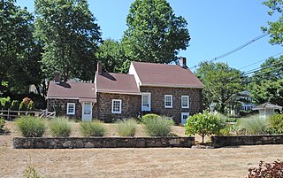
English: - REFERRED TO AS A “TELESCOPE” HOUSE BECAUSE OF THE WAY IT STARTS AS A SMALL HOUSE AND LARGER ADDITIONS WERE BUILT THROUGHOUT THE YEARS. THE SMALLEST SECTION WAS PROBABLY THE ORIGINAL HOUSE, WHICH WAS BUILT FROM C. 1744 TO 1750, WITH A SANDSTONE FOUNDATION. OTHER LARGER SECTIONS WERE ADDED DURING THE YEARS BEFORE THE REVOLUTION. BARENT VAN HORN AND HIS FAMILY WERE BRITISH LOYALISTS, AND THERE WAS A REPORT OF A RAID ON THE HOUSE DURING THE REVOLUTIONARY WAR.
|
||
| Date | |||
| Source | Own work | ||
| Author | JERRYE & ROY KLOTZ MD |
| Camera location | | View this and other nearby images on: OpenStreetMap |
|---|
Licensing
I, the copyright holder of this work, hereby publish it under the following license:
This file is licensed under the Creative Commons Attribution-Share Alike 4.0 International license.
- You are free:
- to share – to copy, distribute and transmit the work
- to remix – to adapt the work
- Under the following conditions:
- attribution – You must give appropriate credit, provide a link to the license, and indicate if changes were made. You may do so in any reasonable manner, but not in any way that suggests the licensor endorses you or your use.
- share alike – If you remix, transform, or build upon the material, you must distribute your contributions under the same or compatible license as the original.
File history
Click on a date/time to view the file as it appeared at that time.
| Date/Time | Thumbnail | Dimensions | User | Comment | |
|---|---|---|---|---|---|
| current | 17:13, 6 September 2015 | | 2,705 × 1,699 (746 KB) | KLOTZPLATE | User created page with UploadWizard |
File usage
The following pages on the English Wikipedia use this file (pages on other projects are not listed):
Global file usage
The following other wikis use this file:
- Usage on www.wikidata.org