
File:Uzicka republika2.png

Size of this preview: 437 × 599 pixels. Other resolutions: 175 × 240 pixels | 503 × 690 pixels.
Original file (503 × 690 pixels, file size: 34 KB, MIME type: image/png)
| This is a file from the Wikimedia Commons. Information from its description page there is shown below. Commons is a freely licensed media file repository. You can help. |
Summary
| Description |
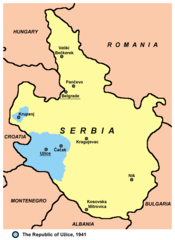
English: A map of the territory controlled by the partisans of Užice - The Republic of Užice. Српски / srpski: Mapa teritorije pod kontrolom partizana - Užičke republike. |
| Date | |
| Source | derivative work (created from this map: http://commons.wikimedia.org/wiki/File:Serbia1941_1944.png - author of that file is User:PANONIAN) |
| Author | George D. Božović (modified version) |
| Other versions |
[]
PNG:
|


Licensing
| I, the copyright holder of this work, release this work into the public domain. This applies worldwide. In some countries this may not be legally possible; if so: I grant anyone the right to use this work for any purpose, without any conditions, unless such conditions are required by law. |
File history
Click on a date/time to view the file as it appeared at that time.
| Date/Time | Thumbnail | Dimensions | User | Comment | |
|---|---|---|---|---|---|
| current | 14:15, 21 April 2013 | | 503 × 690 (34 KB) | PANONIAN | better version, improved aesthetics, borders and descriptions remained unchanged |
| 16:02, 8 September 2010 |  | 421 × 525 (49 KB) | DIREKTOR | Crop | |
| 18:15, 27 October 2007 |  | 447 × 551 (49 KB) | George D. Bozovic | ||
| 14:07, 26 October 2007 |  | 447 × 599 (52 KB) | George D. Bozovic | {{Information |Description=a map of the territory controlled by the partisans of Užice |Source=self-made |Date=26 October 2007 |Author= George D. Božović }} |
File usage
The following pages on the English Wikipedia use this file (pages on other projects are not listed):
Global file usage
The following other wikis use this file:
- Usage on az.wikipedia.org
- Usage on bs.wikipedia.org
- Usage on cs.wikipedia.org
- Usage on de.wikipedia.org
- Usage on el.wikipedia.org
- Usage on fr.wikipedia.org
- Usage on hr.wikipedia.org
- Usage on hu.wikipedia.org
- Usage on it.wikipedia.org
- Usage on ko.wikipedia.org
- Usage on nl.wikipedia.org
- Usage on no.wikipedia.org
- Usage on pt.wikipedia.org
- Usage on ro.wikipedia.org
- Usage on ru.wikipedia.org
- Usage on sh.wikipedia.org
- Usage on tr.wikipedia.org
- Usage on uk.wikipedia.org
- Usage on www.wikidata.org