
File:Uttarpradesh-languages.GIF

Size of this preview: 800 × 564 pixels. Other resolutions: 320 × 225 pixels | 640 × 451 pixels | 1,024 × 722 pixels | 1,175 × 828 pixels.
Original file (1,175 × 828 pixels, file size: 121 KB, MIME type: image/gif)
| This is a file from the Wikimedia Commons. Information from its description page there is shown below. Commons is a freely licensed media file repository. You can help. |
Summary
| Description |
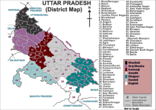
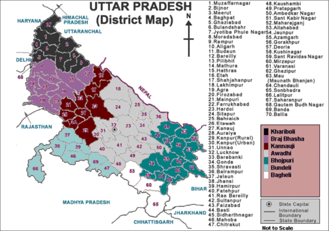
English: A map showing the distribution of various native languages across the different districts of Uttar Pradesh state, India. |
| Date | 18 Nov '08 |
| Source | Own work |
| Author | Maquahuitl, Faizhaider |
| Permission (Reusing this file) |
No |
Licensing
Sayed Mohammad Faiz Haider, the copyright holder of this work, hereby publishes it under the following licenses:
This file is licensed under the Creative Commons Attribution-Share Alike 3.0 Unported license.
Attribution: Sayed Mohammad Faiz Haider
- You are free:
- to share – to copy, distribute and transmit the work
- to remix – to adapt the work
- Under the following conditions:
- attribution – You must give appropriate credit, provide a link to the license, and indicate if changes were made. You may do so in any reasonable manner, but not in any way that suggests the licensor endorses you or your use.
- share alike – If you remix, transform, or build upon the material, you must distribute your contributions under the same or compatible license as the original.

|
Permission is granted to copy, distribute and/or modify this document under the terms of the GNU Free Documentation License, Version 1.2 or any later version published by the Free Software Foundation; with no Invariant Sections, no Front-Cover Texts, and no Back-Cover Texts. A copy of the license is included in the section entitled GNU Free Documentation License. |
You may select the license of your choice.
File history
Click on a date/time to view the file as it appeared at that time.
| Date/Time | Thumbnail | Dimensions | User | Comment | |
|---|---|---|---|---|---|
| current | 14:05, 1 December 2008 | | 1,175 × 828 (121 KB) | Faizhaider | {{Information |Description= |Source= |Date= |Author= |Permission= |other_versions= }} |
| 08:29, 21 November 2008 |  | 600 × 586 (87 KB) | Maquahuitl | {{Information |Description={{en|1=A map showing the distribution of various native languages across the different districts of Uttar Pradesh state, India.}} |Source=Own work by uploader |Author=Maquahuitl |Date=18 Nov '08 |Permission=N |
File usage
The following pages on the English Wikipedia use this file (pages on other projects are not listed):
Global file usage
The following other wikis use this file:
- Usage on bh.wikipedia.org
- Usage on mr.wikipedia.org
- Usage on ne.wikipedia.org
- Usage on ru.wikipedia.org
- Usage on ta.wikipedia.org
- Usage on uk.wikipedia.org