
File:Uruguay fisico-SZ.png

Size of this preview: 471 × 599 pixels. Other resolutions: 188 × 240 pixels | 377 × 480 pixels | 603 × 768 pixels | 1,100 × 1,400 pixels.
Original file (1,100 × 1,400 pixels, file size: 519 KB, MIME type: image/png)
| This is a file from the Wikimedia Commons. Information from its description page there is shown below. Commons is a freely licensed media file repository. You can help. |
Summary
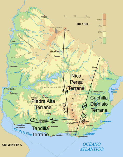
| Description | Topographic map of Uruguay with shear zones and terranes |
| Date | |
| Source | File:Uruguay_fisico.png; geology after Gaucher et al. 2008, Fig. 1. |
| Author | Jordevi; Fama Clamosa |
| Permission (Reusing this file) |
PD-own |
- References
- Gaucher, C.; Finney, S. C.; Poiré, D. G.; Valencia, V. A.; Grove, M.; Blanco, G.; Pamoukaghlián, K.; Peral, L. G. (2008). "Detrital zircon ages of Neoproterozoic sedimentary successions in Uruguay and Argentina: insights into the geological evolution of the Río de la Plata Craton" (PDF). Precambrian Research 167 (1): 150–170. doi:10.1016/j.precamres.2008.07.006
Licensing
| I, the copyright holder of this work, release this work into the public domain. This applies worldwide. In some countries this may not be legally possible; if so: I grant anyone the right to use this work for any purpose, without any conditions, unless such conditions are required by law. |
File history
Click on a date/time to view the file as it appeared at that time.
| Date/Time | Thumbnail | Dimensions | User | Comment | |
|---|---|---|---|---|---|
| current | 15:24, 6 January 2016 | | 1,100 × 1,400 (519 KB) | Fama Clamosa | {{Information |Description=Topographic map of Uruguay with shear zones and terranes |Source=File:Uruguay_fisico.png; geology after Gaucher et al. 2008, Fig. 1. |Date=January 6, 2016 |Author= Jordevi; [[User:Fama Clamosa|Fama Clamo... |
File usage
The following pages on the English Wikipedia use this file (pages on other projects are not listed):
Global file usage
The following other wikis use this file:
- Usage on ar.wikipedia.org
- Usage on es.wikipedia.org
- Usage on hr.wikipedia.org
- Usage on it.wikipedia.org