
File:Ukrainian State 1918.5-11.png

Size of this preview: 800 × 488 pixels. Other resolutions: 320 × 195 pixels | 640 × 390 pixels | 1,024 × 625 pixels | 1,280 × 781 pixels | 1,692 × 1,032 pixels.
Original file (1,692 × 1,032 pixels, file size: 383 KB, MIME type: image/png)
| This is a file from the Wikimedia Commons. Information from its description page there is shown below. Commons is a freely licensed media file repository. You can help. |
| Description |
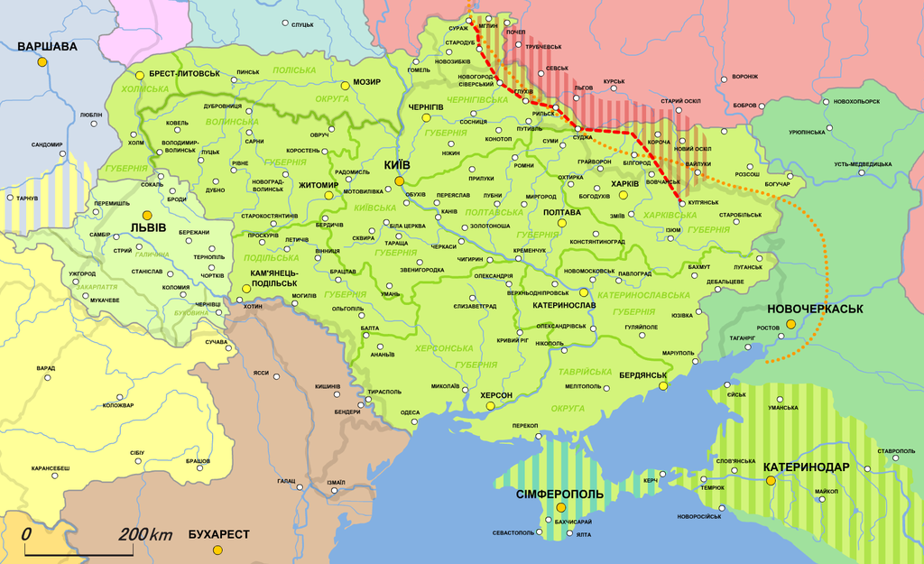
Українська: Карта Української держави (1918.V-XI)
Українська держава
Західноукраїнська народна республіка (від 19.X.1918)
Кримський крайовий уряд (мусив увійти до складу Української держави на правах автономії)
Кубанська народна республіка (мусила увійти до складу Української держави на правах автономії)
Радянська Росія
Межа просування німецько-австрійських військ
Демаркаційна лінія між Україною та Росією
Нейтральна зона між Україною та Росією
English: Map of the Ukrainian State (1918.V-XI)
Ukrainian State
West Ukrainian People's Republic (from 19.X.1918)
Crimean government (planned to join the Ukrainian state as autonomic republic)
Kuban People's Republic (planned to join the Ukrainian state as autonomic republic)
Soviet Russia
日本語: ウクライナ国の地図 (1918年5月‐11月) |
| Date | |
| Source | Own work, based on Українська держава, утворення Директорії та відновлення УНР (травень - листопад 1918 р) // Атлас історії України. 10 клас |
| Author | Alex Tora |
This file is licensed under the Creative Commons Attribution-Share Alike 2.1 Japan license.
- You are free:
- to share – to copy, distribute and transmit the work
- to remix – to adapt the work
- Under the following conditions:
- attribution – You must give appropriate credit, provide a link to the license, and indicate if changes were made. You may do so in any reasonable manner, but not in any way that suggests the licensor endorses you or your use.
- share alike – If you remix, transform, or build upon the material, you must distribute your contributions under the same or compatible license as the original.

.png)
File history
Click on a date/time to view the file as it appeared at that time.
| Date/Time | Thumbnail | Dimensions | User | Comment | |
|---|---|---|---|---|---|
| current | 18:16, 21 January 2022 | | 1,692 × 1,032 (383 KB) | Super Dromaeosaurus | Romania-Ukraine border at Dniester |
| 07:49, 8 February 2011 |  | 1,692 × 1,032 (480 KB) | Alex Tora | {{Information |Description= |Source={{own}} |Date= |Author=Alex Tora |Permission= |other_versions= }} | |
| 02:47, 8 February 2011 |  | 1,690 × 1,022 (445 KB) | Alex Tora | {{Information |Description= |Source={{own}} |Date= |Author=Alex Tora |Permission= |other_versions= }} | |
| 02:38, 8 February 2011 |  | 1,688 × 1,034 (449 KB) | Alex Tora | {{Information |Description={{en|Карта Української держави (1918.V-XI)}}{{en|Map of the Ukrainian State (1918.V-XI)}}{{ja|[[:ja:ウクライナ国|ウクライナ国 |
File usage
The following pages on the English Wikipedia use this file (pages on other projects are not listed):
Global file usage
The following other wikis use this file:
- Usage on azb.wikipedia.org
- Usage on be-tarask.wikipedia.org
- Usage on be.wikipedia.org
- Usage on bg.wikipedia.org
- Usage on bs.wikipedia.org
- Usage on ca.wikipedia.org
- Usage on es.wikipedia.org
- Usage on fr.wikipedia.org
- Usage on hi.wikipedia.org
- Usage on it.wikipedia.org
- Usage on ja.wikipedia.org
- Usage on lt.wikipedia.org
- Usage on lv.wikipedia.org
- Usage on mk.wikipedia.org
- Usage on mt.wikipedia.org
- Usage on ru.wikipedia.org
- Usage on te.wikipedia.org
- Usage on th.wikipedia.org
- Usage on tr.wikipedia.org
- Usage on uk.wikipedia.org
- Usage on uz.wikipedia.org
- Usage on vi.wikipedia.org
- Usage on www.wikidata.org
View more global usage of this file.