
File:US cretaceous general.jpg

No higher resolution available.
US_cretaceous_general.jpg (500 × 338 pixels, file size: 20 KB, MIME type: image/jpeg)
| This is a file from the Wikimedia Commons. Information from its description page there is shown below. Commons is a freely licensed media file repository. You can help. |
Summary
| Description |
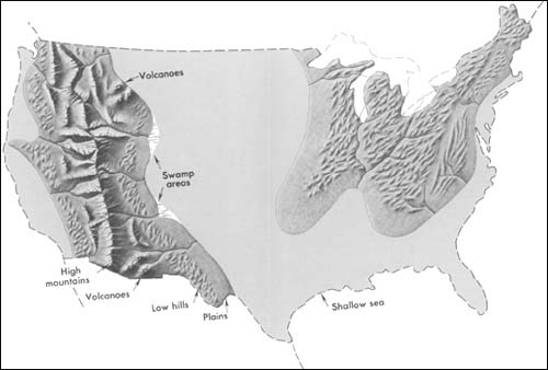
English: Generalized geographic map of the United States in Late Cretaceous time. Note: Eighty million years ago, during the Age of Dinosaurs, the geography of North America was very different from that of today. Mountain ranges have changed considerably since this, the Cretaceous Period. The Appalachian Mountains were probably lower and less conspicuous as a source of sediment than they are today; apparently they supplied appreciable amounts of coarse sediment only in the Southeast (Tennessee, Alabama, Mississippi, and Georgia). The Rocky Mountains, as they are today, did not exist; instead a giant trough in which marine sediment slowly accumulated occupied this part of the West. Shallow, warm inland seas covered large portions of the Southern and Western United States, as shown on the map. Large portions of California were under water, and in eastern California, Nevada, Arizona, Idaho, eastern Oregon, Washington, and Alberta, a belt of the Earth's crust slowly rose to form a new mountain range. Details from this vast highland extended eastward into Utah, Wyoming, Colorado, and New Mexico. Still farther east, Kansas, Nebraska, and adjacent States to the north and south were covered by warm, extensive, but shallow seas in which beds of limestone slowly formed. The Cretaceous Period marked the last extensive covering of the North American continent by the sea. Since then, sea level has dropped and the continent has gradually emerged to its present size and shape. |
| Date | |
| Source | http://pubs.usgs.gov/gip/continents/cretaceous.jpg |
| Author | USGS |
Licensing
This image is in the public domain in the United States because it only contains materials that originally came from the United States Geological Survey, an agency of the United States Department of the Interior. For more information, see the official USGS copyright policy.
|
Original upload log
The original description page was here. All following user names refer to en.wikipedia.
- 2005-04-15 02:44 SEWilco 500×338× (20737 bytes) Generalized geographic map of the [[United States]] in [[Late Cretaceous]] time. Eighty million years ago, during the Age of Dinosaurs, the geography of [[North America]] was very different from that of today. Mountain ranges have changed considerably si
File history
Click on a date/time to view the file as it appeared at that time.
| Date/Time | Thumbnail | Dimensions | User | Comment | |
|---|---|---|---|---|---|
| current | 05:03, 17 June 2011 | | 500 × 338 (20 KB) | File Upload Bot (Magnus Manske) | {{BotMoveToCommons|en.wikipedia|year={{subst:CURRENTYEAR}}|month={{subst:CURRENTMONTHNAME}}|day={{subst:CURRENTDAY}}}} {{Information |Description={{en|Generalized geographic map of the en:United States in en:Late Cretaceous time. Eighty mill |
File usage
The following pages on the English Wikipedia use this file (pages on other projects are not listed):
Global file usage
The following other wikis use this file:
- Usage on ar.wikipedia.org
- Usage on sh.wikipedia.org