
File:USGS Shakemap - 1987 Whittier Narrows earthquake.jpg

Size of this preview: 478 × 599 pixels. Other resolutions: 191 × 240 pixels | 383 × 480 pixels | 613 × 768 pixels | 817 × 1,024 pixels | 1,692 × 2,120 pixels.
Original file (1,692 × 2,120 pixels, file size: 1.83 MB, MIME type: image/jpeg)
| This is a file from the Wikimedia Commons. Information from its description page there is shown below. Commons is a freely licensed media file repository. You can help. |
Summary
| Description |
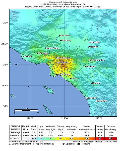
English: USGS ShakeMap for the 1987 Whittier Narrows earthquake |
| Date | |
| Source | https://earthquake.usgs.gov/earthquakes/eventpage/ci731691/shakemap/intensity |
| Author | United States Geological Survey |
Licensing
This image is in the public domain in the United States because it only contains materials that originally came from the United States Geological Survey, an agency of the United States Department of the Interior. For more information, see the official USGS copyright policy.
|
File history
Click on a date/time to view the file as it appeared at that time.
| Date/Time | Thumbnail | Dimensions | User | Comment | |
|---|---|---|---|---|---|
| current | 07:17, 20 May 2020 | | 1,692 × 2,120 (1.83 MB) | Tinh1000000 | ATLAS 2020-02-06 revision |
| 03:20, 15 March 2014 |  | 612 × 719 (164 KB) | Dawnseeker2000 | User created page with UploadWizard |
File usage
No pages on the English Wikipedia use this file (pages on other projects are not listed).
Global file usage
The following other wikis use this file:
- Usage on fr.wikipedia.org
- Usage on www.wikidata.org