
File:USA Guam satellite image location map.jpg

Size of this preview: 600 × 600 pixels. Other resolutions: 240 × 240 pixels | 480 × 480 pixels | 768 × 768 pixels | 1,200 × 1,200 pixels.
Original file (1,200 × 1,200 pixels, file size: 540 KB, MIME type: image/jpeg)
| This is a file from the Wikimedia Commons. Information from its description page there is shown below. Commons is a freely licensed media file repository. You can help. |
Summary
| Description |
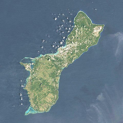
Quadratische Plattkarte, N-S-Streckung 100.0 %. Geographische Begrenzung der Karte: Equirectangular projection, N/S stretching 100.0 %. Geographic limits of the map:
|
| Date | |
| Source | NASA, Landsat7 visual, http://onearth.jpl.nasa.gov |
| Author | Alexrk2 |
| Other versions |
|


|
This map has been made or improved in the German Kartenwerkstatt (Map Lab). You can propose maps to improve as well.
|
Licensing
I, the copyright holder of this work, hereby publish it under the following license:
This file is licensed under the Creative Commons Attribution-Share Alike 3.0 Unported license.
- You are free:
- to share – to copy, distribute and transmit the work
- to remix – to adapt the work
- Under the following conditions:
- attribution – You must give appropriate credit, provide a link to the license, and indicate if changes were made. You may do so in any reasonable manner, but not in any way that suggests the licensor endorses you or your use.
- share alike – If you remix, transform, or build upon the material, you must distribute your contributions under the same or compatible license as the original.
File history
Click on a date/time to view the file as it appeared at that time.
| Date/Time | Thumbnail | Dimensions | User | Comment | |
|---|---|---|---|---|---|
| current | 17:05, 14 March 2010 | | 1,200 × 1,200 (540 KB) | Alexrk2 | == Beschreibung == {{Information |Description= {{de|Satellitenfoto von Guam, USA}} Quadratische Plattkarte, N-S-Streckung 100.0 %. Geographische Begrenzung der Karte: {{en|Satellite Image of Guam, USA}} Eq |
File usage
More than 100 pages use this file. The following list shows the first 100 pages that use this file only. A full list is available.
- Agaga River
- Agat Bay
- Agfayan River
- Aguada River
- Ajayan River
- Alatgue River
- Almagosa River
- Aplacho River
- Asalonso River
- Aslinget River
- Asmafines River
- Astaban River
- Atantano River
- Atate River
- Big Guatali River
- Bile River
- Bolanos River
- Bonya River
- Bubulao River
- Cetti River
- Chagame River
- Chaot River
- Cocos Lagoon
- Dante River
- Fena Lake
- Fensol River
- Fintasa River
- Fonte River
- Gaan River
- Gautali River
- Geus River
- Guam National Wildlife Refuge
- Guam Open
- Hagåtña River
- Ieygo River
- Imong River
- Inarajan River
- La Sa Fua River
- Laelae River
- Laguan River
- Laguas River
- Laolao River
- Liyog River
- Lonfit River
- Maagas River
- Madofan River
- Madog River
- Maemong River
- Mahlac River
- Malaja River
- Manell River
- Manengon River
- Masso River
- Matgue River
- Maulap River
- Mount Alifan
- Mount Almagosa
- Mount Bolanos
- Mount Jumullong Manglo
- Mount Lamlam
- Mount Llicho
- Namo River
- Nelansa River
- Pago Bay
- Pago River
- Pasamano River
- Paulana River
- Pauliluc River
- Pigua River
- Sadog Gago River
- Sagge River
- Sagua River
- Salinas River (Guam)
- San Nicolas River
- Sarasa River
- Sasa River
- Sella River (Guam)
- Sigua River
- Sumay River
- Suyafe River
- Taguag River
- Taleyfac River
- Talisay River
- Talofofo Bay
- Talofofo River
- Tarzan River
- Tenjo River
- Tinago River
- Tinechong River
- Togcha River
- Toguan River
- Tolaeyuus River
- Topony River
- Ugum River
- Umatac River
- War in the Pacific National Historical Park
- Yledigao River
- User:Michael!/Project:Location map templates/United States
- Module:Location map/data/Guam
- Module:Location map/data/USA Guam
View more links to this file.
Global file usage
The following other wikis use this file:
- Usage on af.wikipedia.org
- Usage on ar.wikipedia.org
- Usage on ast.wikipedia.org
- Usage on az.wikipedia.org
- Usage on bcl.wikipedia.org
- Usage on be.wikipedia.org
- Usage on bg.wikipedia.org
- Usage on ceb.wikipedia.org
- Usage on ce.wikipedia.org
- Usage on cs.wikipedia.org
- Usage on da.wikipedia.org
- Usage on de.wikipedia.org
- Usage on de.wikivoyage.org
- Usage on eo.wikipedia.org
- Usage on fa.wikipedia.org
- Usage on frr.wikipedia.org
- Usage on fr.wikipedia.org
- Usage on he.wikipedia.org
- Usage on hr.wikipedia.org
- Usage on hy.wikipedia.org
- Usage on id.wikipedia.org
- Usage on it.wikivoyage.org
- Usage on ja.wikipedia.org
- Usage on kk.wikipedia.org
- Usage on kn.wikipedia.org
- Usage on ko.wikipedia.org
- Usage on lv.wikipedia.org
- Usage on mk.wikipedia.org
- Usage on ms.wikipedia.org
- Usage on pl.wikipedia.org
View more global usage of this file.