
File:USA Groundwater and Soil moisture Drought Map.jpg
No higher resolution available.
USA_Groundwater_and_Soil_moisture_Drought_Map.jpg (560 × 420 pixels, file size: 189 KB, MIME type: image/jpeg)
| This is a file from the Wikimedia Commons. Information from its description page there is shown below. Commons is a freely licensed media file repository. You can help. |
Summary
| Description |
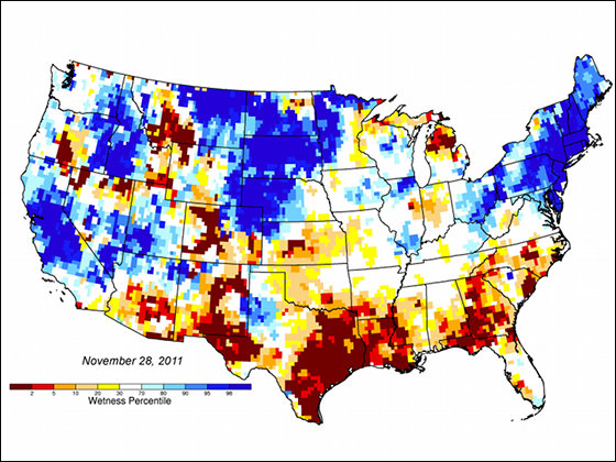
English: The map uses an 11-point scale where blue measures wetter than normal conditions and yellow/red drier than normal conditions |
| Date | |
| Source | https://climate.nasa.gov/news/632/nasas-grace-helps-monitor-us-drought/ |
| Author | NASA |
Licensing
| This file is in the public domain in the United States because it was solely created by NASA. NASA copyright policy states that "NASA material is not protected by copyright unless noted". (See Template:PD-USGov, NASA copyright policy page or JPL Image Use Policy.) | ||
 |
Warnings:
|
File history
Click on a date/time to view the file as it appeared at that time.
| Date/Time | Thumbnail | Dimensions | User | Comment | |
|---|---|---|---|---|---|
| current | 22:07, 8 May 2017 | | 560 × 420 (189 KB) | Bonil009 | User created page with UploadWizard |
File usage
The following pages on the English Wikipedia use this file (pages on other projects are not listed):
- Wildfire
- User talk:Abyssal
- User talk:AfroThundr3007730/Newsletters/Archive 1
- User talk:Ancheta Wis/Archive 6
- User talk:Andrewa/Archive 14
- User talk:Armanaziz/Archive05
- User talk:Ask123
- User talk:Auric/Archive 15
- User talk:Avicenno
- User talk:Bahb the Illuminated
- User talk:Balablitz/Archive 20
- User talk:BusterD/Archive 15
- User talk:Cactus.man/Archive 15
- User talk:Charlesdrakew/Archives/2018/August
- User talk:Chouette254
- User talk:Cplakidas/Archive 22
- User talk:DavidCane/Archives/Archive 11
- User talk:Ddstretch/Archives/2018/July
- User talk:Dunarc
- User talk:Eruditescholar/2018a
- User talk:Espilio
- User talk:Evad37/Archive 7
- User talk:Finnusertop/Archive/2018
- User talk:Greatedits1/Archive 1
- User talk:Grey Wanderer/Archive 8
- User talk:Hawkeye7/Archive 2018
- User talk:Iazyges/Archives/2018/July
- User talk:Javert2113/Archive 2
- User talk:Keith D/Archive 66
- User talk:Kpgjhpjm/Archive 3
- User talk:L3X1/Archive 6
- User talk:LightandDark2000/Archive 3
- User talk:Master of Time/Archive 4
- User talk:Mercurywoodrose/Archive13
- User talk:Nerd1a4i/Archive 3
- User talk:Nick Moyes/Archive 11
- User talk:Nigos/Archive 3
- User talk:Nolan Perry/Archive 2
- User talk:Northamerica1000/Archive 84
- User talk:OdysseusTroy
- User talk:OhanaUnited/Archive 25
- User talk:Paulmcdonald/Archives/2022/February
- User talk:Pbsouthwood/Archive 10
- User talk:PratyushSinha101/Archive 3
- User talk:RL0919/Archive 2018
- User talk:Railfan01
- User talk:Redolta/Archives 2018-2021
- User talk:Robertgombos/Archive 5
- User talk:SMcCandlish/Archive 140
- User talk:Samee/Archives/2018/July
- User talk:Serenesage
- User talk:Simon Burchell/Archive 19
- User talk:SirGents
- User talk:Slambo/Archives/2018/July
- User talk:Teblick/Archive 4
- User talk:The Grid/Archive 7
- User talk:Tisquesusa/Archive 5
- User talk:Trinitrobrick/Archive 1
- User talk:Vermont/Archive 9
- User talk:Vishal14k
- User talk:Waggers/Archive 26
- User talk:WikiWikiWayne/Archive 40
- User talk:Wumbolo/Archive 2
- User talk:Ww2censor/Archive32
- User talk:Tom
- Wikipedia:WikiProject Portals/Newsletter archive
Global file usage
The following other wikis use this file:
- Usage on cs.wikipedia.org
- Usage on zh.wikipedia.org