
File:USACE Barrier Dam Lake Saylorville.jpg

Size of this preview: 800 × 533 pixels. Other resolutions: 320 × 213 pixels | 640 × 427 pixels | 1,024 × 683 pixels | 1,500 × 1,000 pixels.
Original file (1,500 × 1,000 pixels, file size: 393 KB, MIME type: image/jpeg)
| This is a file from the Wikimedia Commons. Information from its description page there is shown below. Commons is a freely licensed media file repository. You can help. |
| Description |
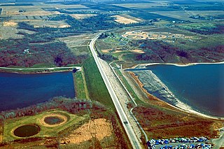
English: Barrier Dam on Saylorville Lake near Polk City, Iowa, USA. The main dam is Saylorville Dam, but in order to fill the lake, this second dam, Barrier Dam had to be constructed on one arm of the lake. |
|||
| Date | not specified or unknown | |||
| Source |
U.S. Army Corps of Engineers Digital Visual Library Image page Image description page Digital Visual Library home page |
|||
| Author | U.S. Army Corps of Engineers, photographer not specified or unknown | |||
| Permission (Reusing this file) |
|
| Camera location | | View this and other nearby images on: OpenStreetMap |
|---|
File history
Click on a date/time to view the file as it appeared at that time.
| Date/Time | Thumbnail | Dimensions | User | Comment | |
|---|---|---|---|---|---|
| current | 00:27, 3 April 2007 | | 1,500 × 1,000 (393 KB) | DanMS | {{Information | Description = {{en|Barrier Dam on Saylorville Lake near Polk City, Iowa, USA. The main dam is Saylorville Dam, but in order to fill the lake, this second dam, Barrier Dam had to be constructed on one arm of the lake. }} | Source |
File usage
The following pages on the English Wikipedia use this file (pages on other projects are not listed):
Global file usage
The following other wikis use this file:
- Usage on en.wikivoyage.org
- Usage on es.wikipedia.org
- Usage on hu.wikipedia.org
- Usage on it.wikivoyage.org
- Usage on ru.wikipedia.org
- Usage on www.wikidata.org