
File:UNR 2.1918 Brest-Litovsk.png
Size of this preview: 800 × 487 pixels. Other resolutions: 320 × 195 pixels | 640 × 389 pixels | 1,024 × 623 pixels | 1,280 × 779 pixels | 1,698 × 1,033 pixels.
Original file (1,698 × 1,033 pixels, file size: 432 KB, MIME type: image/png)
| This is a file from the Wikimedia Commons. Information from its description page there is shown below. Commons is a freely licensed media file repository. You can help. |
Summary
| Description |
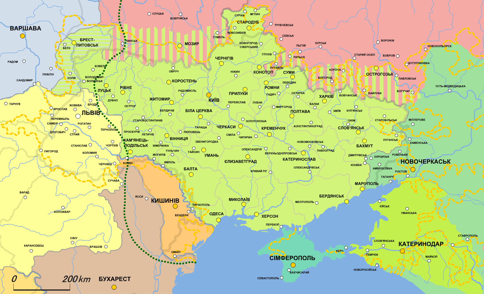
English: Map of the Ukrainian People's Republic (1918.II))
UPR according to the Treaty of Brest-Litovsk)
Disputed territories
Borders of residence of Ukrainians
Limits of the advance of German-Austrian troops in autumn 1917
Podlachia, transferred to the UPR under the terms of the Treaty of Brest-Litovsk
Soviet Russia
Don regional government of General Krasnov
Kuban regional government
Crimean Tatar government
Austro-Hungarian Empire
Polish Regency Council
Kingdom of Romania
Moldovan People's Republic
Serbia Українська: Карта Української Народної Республіки (1918.II)
УНР за Брест-Литовським договором)
Спірні території
Межі проживання українців
Межі просування німецько-австрійських військ восени 1917
Підляшшя, передане УНР за умовами Брест-Литовського договору
Радянська Росія
Донський крайовий уряд генерала Краснова
Кубанський крайовий уряд
Кримсько-татарський уряд
Австро-Угорська Імперія
Польська регентська рада
Румунське королівство
Молдавська народна республіка
Сербія |
| Date | |
| Source | Own work, based on Початок визвольних змагань українського народу. Утворення УНР (березень 1917 - березень 1918 р) // Атлас історії України. 10 клас |
| Author | Alex Tora |
This file is licensed under the Creative Commons Attribution-Share Alike 2.1 Japan license.
- You are free:
- to share – to copy, distribute and transmit the work
- to remix – to adapt the work
- Under the following conditions:
- attribution – You must give appropriate credit, provide a link to the license, and indicate if changes were made. You may do so in any reasonable manner, but not in any way that suggests the licensor endorses you or your use.
- share alike – If you remix, transform, or build upon the material, you must distribute your contributions under the same or compatible license as the original.


|
This historical map image could be re-created using vector graphics as an SVG file. This has several advantages; see Commons:Media for cleanup for more information. If an SVG form of this image is available, please upload it and afterwards replace this template with
{{vector version available|new image name}}.
It is recommended to name the SVG file “UNR 2.1918 Brest-Litovsk.svg”—then the template Vector version available (or Vva) does not need the new image name parameter. |
File history
Click on a date/time to view the file as it appeared at that time.
| Date/Time | Thumbnail | Dimensions | User | Comment | |
|---|---|---|---|---|---|
| current | 18:14, 21 January 2022 | | 1,698 × 1,033 (432 KB) | Super Dromaeosaurus | Romania-Ukraine border at Dniester |
| 13:30, 21 January 2012 |  | 1,698 × 1,033 (535 KB) | Alex Tora | {{Information |Description={{uk|Карта Української Народної Республіки (1918.II)}} {{legend|#A0FF53|УНР за Брест-Литовським договором (17 серпня 1917)}} {{Legend|#A0FF53|Спірні те |
File usage
The following pages on the English Wikipedia use this file (pages on other projects are not listed):
Global file usage
The following other wikis use this file:
- Usage on ca.wikipedia.org
- Usage on es.wikipedia.org
- Usage on fr.wikipedia.org
- Usage on it.wikipedia.org
- Usage on lv.wikipedia.org
- Usage on mk.wikipedia.org
- Usage on mt.wikipedia.org
- Usage on ru.wikipedia.org
- Usage on th.wikipedia.org
- Usage on uk.wikipedia.org
- Usage on vi.wikipedia.org
- Usage on zh.wikipedia.org