File:UBBasel Map 1600 Kartenslg Mappe 97-40c.tif

Page contents not supported in other languages.
This is a file from the Wikimedia Commons
From Wikipedia, the free encyclopedia

Original file(11,195 × 7,403 pixels, file size: 237.14 MB, MIME type: image/tiff, 2 pages)

Summary

Warning The original file is very high-resolution. It might not load properly or could cause your browser to freeze when opened at full size.
Title
La nuova citta e fortezza di Malta chiamata Valletta
Description
La nuova citta e fortezza di Malta chiamata Valletta
Date 1600s
date QS:P,+1600-00-00T00:00:00Z/8
Source 10.3931/e-rara-12626 : Info: Kartenportal.CH
Creator
anonymous    wikidata:Q4233718 s:en:Portal:Anonymous texts
 
anonymous
Alternative names
Unknown authorUnknown author
Description artist
Authority file
creator QS:P170,Q4233718
; based on work by
Matteo Perez d'Aleccio  (1547–1616)  wikidata:Q927064
 
Matteo Perez d'Aleccio
Description painter and sculptor
Date of birth/death 1547 Edit this at Wikidata 1616 Edit this at Wikidata
Location of birth/death Alezio Lima
Authority file
creator QS:P170,Q927064
Permission
(Reusing this file)
Public domain

This work is in the public domain in its country of origin and other countries and areas where the copyright term is the author's life plus 100 years or fewer.


This work is in the public domain in the United States because it was published (or registered with the U.S. Copyright Office) before January 1, 1929.

Public domain The document is in the public domain. It may be used without restrictions. The Basel University Library recommends that the name of the source of the original document is mentioned when the document is used.

Recommended forms of attribution:
English: Basel University Library, Kartenslg Mappe 97:40c
German: Universitätsbibliothek Basel, Kartenslg Mappe 97:40c
French: Bibliothèque publique et universitaire de Bâle-Ville, Kartenslg Mappe 97:40c

 Geotemporal data
Scale Ca. 1:3 300
Bounding box
N: 35.8914°N
W: 14.5039°E E: 14.5211°E
S: 35.9042°N
Georeferencing Georeference the map in Wikimaps Warper If inappropriate please set warp_status = skip to hide.
 Bibliographic data
Language lat
Printed by
In Roma, s.n.
 Archival data
institution QS:P195,Q683842
Accession number
Dimensions height: 32 cm (12.5 in); width: 45 cm (17.7 in)
dimensions QS:P2048,32U174728
dimensions QS:P2049,45U174728
Medium Kupferdruck
Notes 
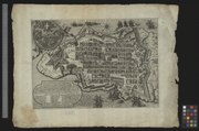
In Roma appresso Mattieo Perez de Allecio / Südostorientiert / Wappenkartusche oben links, Kartusche mit Erläuterungen und Legende unten links, Massstab rechts
Other versions

Captions

Add a one-line explanation of what this file represents

Items portrayed in this file

depicts

image/tiff

File history

Click on a date/time to view the file as it appeared at that time.

Date/TimeThumbnailDimensionsUserComment
current10:59, 25 August 2015Thumbnail for version as of 10:59, 25 August 201511,195 × 7,403, 2 pages (237.14 MB)Basel University LibraryGWToolset: Creating mediafile for Basel University Library.
The following pages on the English Wikipedia use this file (pages on other projects are not listed):

Global file usage

The following other wikis use this file:

Metadata