
File:U-Bahn Berlin - Netzplan.svg

Size of this PNG preview of this SVG file: 800 × 484 pixels. Other resolutions: 320 × 194 pixels | 640 × 387 pixels | 1,024 × 619 pixels | 1,280 × 774 pixels | 2,560 × 1,548 pixels | 1,660 × 1,004 pixels.
Original file (SVG file, nominally 1,660 × 1,004 pixels, file size: 2.07 MB)
| This is a file from the Wikimedia Commons. Information from its description page there is shown below. Commons is a freely licensed media file repository. You can help. |
Summary
| Description |
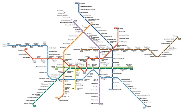
Deutsch: Netzplan der U-Bahn Berlin.
English: Map of the Berlin U-Bahn
Français : Plan du métro de Berlin.
Italiano: Mappa della metropolitana di Berlino.
中文:柏林地铁路线图 |
|||
| Source | Own work | |||
| Author | Arbalete | |||
| Permission (Reusing this file) |
I, the copyright holder of this work, hereby publish it under the following license: This file is licensed under the Creative Commons Attribution-Share Alike 4.0 International license.
|
|||
| Other versions |
|


File history
Click on a date/time to view the file as it appeared at that time.
| Date/Time | Thumbnail | Dimensions | User | Comment | |
|---|---|---|---|---|---|
| current | 00:07, 19 April 2023 | | 1,660 × 1,004 (2.07 MB) | Adrio | Namen und Zusatzbezeichnungen an BVG-Netzplan angepasst; U6 bis 2025 nur bis Kurt-Schumacher-Platz |
| 16:02, 9 July 2021 |  | 1,660 × 1,004 (2.15 MB) | Arbalete | Update (new station Museumsinsel opened on 9th July 2021) | |
| 18:55, 8 June 2021 |  | 1,660 × 1,004 (2.15 MB) | Arbalete | Station korrigiert (Leopoldstraße → Leopoldplatz) | |
| 02:25, 5 December 2020 |  | 1,660 × 1,004 (2.15 MB) | Arbalete | Berliner Rathaus -> Rotes Rathaus | |
| 22:02, 2 December 2020 |  | 1,660 × 1,004 (248 KB) | Arbalete | New line U5 to Hauptbahnhof | |
| 16:23, 16 September 2020 |  | 1,660 × 1,004 (338 KB) | Adrio | Station korrigiert (Joachimsthaler → Johannisthaler) | |
| 13:03, 5 July 2020 |  | 1,660 × 1,004 (251 KB) | Arbalete | Uploaded own work with UploadWizard |
File usage
The following pages on the English Wikipedia use this file (pages on other projects are not listed):
Global file usage
The following other wikis use this file:
- Usage on ar.wikipedia.org
- Usage on be-tarask.wikipedia.org
- Usage on be.wikipedia.org
- Usage on bg.wikipedia.org
- Usage on ca.wikipedia.org
- Usage on cs.wikipedia.org
- Usage on da.wikipedia.org
- Usage on de.wikipedia.org
- Usage on eo.wikipedia.org
- Usage on es.wikipedia.org
- Usage on et.wikipedia.org
- Usage on eu.wikipedia.org
- Usage on fa.wikipedia.org
- Usage on fa.wikivoyage.org
- Usage on fi.wikipedia.org
- Usage on fi.wikivoyage.org
- Usage on fr.wikipedia.org
- Métro de Berlin
- Alexanderplatz (métro de Berlin)
- Hauptbahnhof (métro de Berlin)
- Brandenburger Tor (métro de Berlin)
- Bundestag (métro de Berlin)
- Unter den Linden (métro de Berlin)
- Schillingstraße (métro de Berlin)
- Strausberger Platz (métro de Berlin)
- Weberwiese (métro de Berlin)
- Frankfurter Tor (métro de Berlin)
- Magdalenenstraße (métro de Berlin)
- Elsterwerdaer Platz (métro de Berlin)
- Cottbusser Platz (métro de Berlin)
- Friedrichsfelde (métro de Berlin)
- Tierpark (métro de Berlin)
- Biesdorf-Süd (métro de Berlin)
- Kienberg (métro de Berlin)
- Kaulsdorf-Nord (métro de Berlin)
- Wuhletal (métro de Berlin)
- Britz-Süd (métro de Berlin)
- Neukölln (métro de Berlin)
- Rotes Rathaus (métro de Berlin)
- Lichtenberg (métro de Berlin)
- Frankfurter Allee (métro de Berlin)
- Samariterstraße (métro de Berlin)
- Augsburger Straße (métro de Berlin)
- Museumsinsel (métro de Berlin)
- Carte topologique
- Usage on he.wikipedia.org
View more global usage of this file.