
File:Txu-oclc-6654394-nl-44-2nd-ed.jpg

Size of this preview: 469 × 600 pixels. Other resolutions: 188 × 240 pixels | 375 × 480 pixels | 600 × 768 pixels | 800 × 1,024 pixels | 1,601 × 2,048 pixels | 4,350 × 5,564 pixels.
Original file (4,350 × 5,564 pixels, file size: 6.05 MB, MIME type: image/jpeg)
| This is a file from the Wikimedia Commons. Information from its description page there is shown below. Commons is a freely licensed media file repository. You can help. |
Summary
| Description |
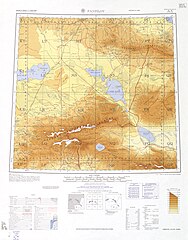
English: Map of Zharkent (Panfilov), Panfilov District, Almaty Region, Kazakhstan (then part of the USSR) and surrounding region from the International Map of the World 1:1,000,000 |
| Date | Printed August 1962; Scanned 2007-06-18 07:40:17 |
| Source | Courtesy of the University of Texas Libraries, The University of Texas at Austin. ([1]) |
| Author | Army Map Serivce (LU), Corps of Engineers, 1960 |
-
 Index Map

![[1]](http://legacy.lib.utexas.edu/maps/imw/txu-oclc-6654394-nl-44-2nd-ed.jpg)
Licensing
This image or file is a work of a U.S. Army Corps of Engineers soldier or employee, taken or made as part of that person's official duties. As a work of the U.S. federal government, the image is in the public domain.
|
File history
Click on a date/time to view the file as it appeared at that time.
| Date/Time | Thumbnail | Dimensions | User | Comment | |
|---|---|---|---|---|---|
| current | 15:08, 15 November 2016 | | 4,350 × 5,564 (6.05 MB) | Panoramio upload bot | == {{int:filedesc}} == {{Information |description=Panfilov NL-44 (1960) |date={{Original upload date|2011-03-08}} |source=http://www.panoramio.com/photo/49172736 |author=[http://www.panoramio.com/user/5628077?with_photo_id=49172736 www.almatymaps.kz] |... |
| 06:07, 7 December 2019 |  | 4,350 × 5,564 (6.05 MB) | Geographyinitiative | User created page with UploadWizard |
File usage
The following pages on the English Wikipedia use this file (pages on other projects are not listed):
Global file usage
The following other wikis use this file:
- Usage on it.wikipedia.org
- Usage on uz.wikipedia.org
- Usage on zh.wikipedia.org