
File:Tuwakarte2.png

Size of this preview: 800 × 560 pixels. Other resolutions: 320 × 224 pixels | 640 × 448 pixels | 1,024 × 717 pixels | 1,206 × 844 pixels.
Original file (1,206 × 844 pixels, file size: 544 KB, MIME type: image/png)
| This is a file from the Wikimedia Commons. Information from its description page there is shown below. Commons is a freely licensed media file repository. You can help. |
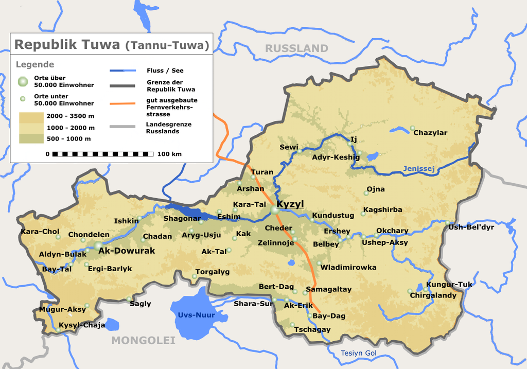
Karte von Tannu-Tuwa, einem Teil Russlands
Lizenz: Das Bild wurde von Roger Zenner gezeichnet und wurde unter der CC-by-sa veröffentlicht.
- Version 2.5: Grenzen überdecken nun Flüsse und Straßen
- Version 2.0: Typo korrigiert
- Version 1.5: Reliefkarte von Tuwa
Source: German Wikipedia, original upload see file history
This file is licensed under the Creative Commons Attribution-Share Alike 2.0 Germany license.
- You are free:
- to share – to copy, distribute and transmit the work
- to remix – to adapt the work
- Under the following conditions:
- attribution – You must give appropriate credit, provide a link to the license, and indicate if changes were made. You may do so in any reasonable manner, but not in any way that suggests the licensor endorses you or your use.
- share alike – If you remix, transform, or build upon the material, you must distribute your contributions under the same or compatible license as the original.

File history German Wikipedia
(Löschen) (Aktuell) 16:16, 18. Sep 2004 . . Roger Zenner . . 1206x844 (557023 Byte) (Karte von Tannu-Tuwa, einem Teil Russlands, Version 2.5)
(Löschen) (Zurücksetzen) 06:15, 18. Sep 2004 . . Roger Zenner . . 1206x844 (556465 Byte) (Tuwa Karte Version 2.01 (Typo korrigiert))
(Löschen) (Zurücksetzen) 03:28, 18. Sep 2004 . . Roger Zenner . . 1206x844 (556344 Byte) (neue Karte von Tuwa)
File history
Click on a date/time to view the file as it appeared at that time.
| Date/Time | Thumbnail | Dimensions | User | Comment | |
|---|---|---|---|---|---|
| current | 19:47, 19 September 2005 | | 1,206 × 844 (544 KB) | Saperaud~commonswiki | Karte von Tannu-Tuwa, einem Teil Russlands Lizenz: Das Bild wurde von Benutzer:Roger_Zenner gezeichnet und wurde unter der CC-by-sa veröffentlicht. *Version 2.5: Grenzen überdecken nun Flüsse und Straßen *Version 2.0: Typo korrigiert *Version 1 |
File usage
The following pages on the English Wikipedia use this file (pages on other projects are not listed):
Global file usage
The following other wikis use this file:
- Usage on af.wikipedia.org
- Usage on ar.wikipedia.org
- Usage on ast.wikipedia.org
- Usage on azb.wikipedia.org
- Usage on az.wikipedia.org
- Usage on be-tarask.wikipedia.org
- Usage on be.wikipedia.org
- Usage on bg.wikipedia.org
- Usage on br.wikipedia.org
- Usage on bxr.wikipedia.org
- Usage on ca.wikipedia.org
- Usage on da.wikipedia.org
- Usage on de.wikipedia.org
- Usage on de.wikivoyage.org
- Usage on es.wikipedia.org
- Usage on eu.wikipedia.org
- Usage on fa.wikipedia.org
- Usage on fi.wikipedia.org
- Usage on fr.wikipedia.org
- Usage on it.wikipedia.org
- Usage on ja.wikipedia.org
- Usage on li.wikipedia.org
- Usage on mk.wikipedia.org
- Usage on nl.wikipedia.org
- Usage on nn.wikipedia.org
- Usage on no.wikipedia.org
- Usage on pl.wikipedia.org
View more global usage of this file.