
File:Tunnel-du-Rove72.JPG

Size of this preview: 800 × 600 pixels. Other resolutions: 320 × 240 pixels | 640 × 480 pixels | 1,024 × 768 pixels | 1,080 × 810 pixels.
Original file (1,080 × 810 pixels, file size: 372 KB, MIME type: image/jpeg)
| This is a file from the Wikimedia Commons. Information from its description page there is shown below. Commons is a freely licensed media file repository. You can help. |
Summary
| Description |
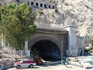
English: The termination of the Canal de Marseille via the southern portal for the Rove Tunnel at Corbière, on the coast between the Corbière nautic base and Port de la Lave, in the quarter Les Riaux to the north-west of Marseille, in the 16th arrondissement. The canal portal is also a bridge over which passes the Route du Rove, running along the coast at the foot of mountain range of L'Estaque. Above again is an input gallery to another tunnel through the mountain, for the railway line going from l'Estaque to Miramas. Français : L'extrémité du canal de Marseille par la porte sud du tunnel du Rove, au lieu dit Corbière, sur la côte entre la base nautique de Corbière et le port de la Lave, dans le quartier des Riaux au nord-ouest de Marseille, dans le 16e arrondissement. La porte du canal forme également un pont sur lequel passe la Route du Rove, qui longe la côte au pied du Massif de l'Estaque. Au dessus encore, on aperçoit la galerie d'entrée d'un autre tunnel sous la montagne, dans lequel passe la ligne de chemin de fer de l'Estaque à Miramas. |
| Date | |
| Source | Own work |
| Author | Fr.Latreille |
| Camera location | | View this and other nearby images on: OpenStreetMap |
|---|
Licensing
I, the copyright holder of this work, hereby publish it under the following licenses:

|
Permission is granted to copy, distribute and/or modify this document under the terms of the GNU Free Documentation License, Version 1.2 or any later version published by the Free Software Foundation; with no Invariant Sections, no Front-Cover Texts, and no Back-Cover Texts. A copy of the license is included in the section entitled GNU Free Documentation License. |
This file is licensed under the Creative Commons Attribution-Share Alike 3.0 Unported, 2.5 Generic, 2.0 Generic and 1.0 Generic license.
- You are free:
- to share – to copy, distribute and transmit the work
- to remix – to adapt the work
- Under the following conditions:
- attribution – You must give appropriate credit, provide a link to the license, and indicate if changes were made. You may do so in any reasonable manner, but not in any way that suggests the licensor endorses you or your use.
- share alike – If you remix, transform, or build upon the material, you must distribute your contributions under the same or compatible license as the original.
You may select the license of your choice.
File history
Click on a date/time to view the file as it appeared at that time.
| Date/Time | Thumbnail | Dimensions | User | Comment | |
|---|---|---|---|---|---|
| current | 14:41, 4 December 2008 | | 1,080 × 810 (372 KB) | Fr.Latreille | {{Information |Description={{fr|1=L'entrée du tunnel du Rove au lieu dit Corbière, au nord-ouest de Marseille. Au-dessus du tunnel, on aperçoit une galerie dans laquelle passe la ligne de chemin de fer de l'Estaque à Miramas}} |Source=travail personne |
File usage
The following pages on the English Wikipedia use this file (pages on other projects are not listed):
Global file usage
The following other wikis use this file:
- Usage on de.wikipedia.org
- Usage on es.wikipedia.org
- Usage on fr.wikipedia.org
- Usage on nl.wikipedia.org
- Usage on pt.wikipedia.org
- Usage on ro.wikipedia.org
- Usage on sv.wikipedia.org
- Usage on www.wikidata.org