
File:Trumpan Church - geograph.org.uk - 768999.jpg
No higher resolution available.
Trumpan_Church_-_geograph.org.uk_-_768999.jpg (640 × 416 pixels, file size: 131 KB, MIME type: image/jpeg)
| This is a file from the Wikimedia Commons. Information from its description page there is shown below. Commons is a freely licensed media file repository. You can help. |
Summary
| Description |
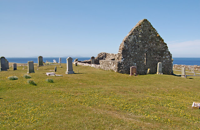
English: Trumpan Church Trumpan Church was the site in 1578 of a revenge attack by the MacDonalds of Uist on the MacLeods. The MacDonalds crept up on the church, which was filled by a worshipping congregation. They barred the only door and set fire to the thatch, killing all the occupants save one young girl. She died of her injuries, but was instrumental in raising the alarm and thus securing the butchering of all the MacDonalds by the men of MacLeod of Dunvegan. |
| Date | |
| Source | From geograph.org.uk |
| Author | John Allan |
| Attribution (required by the license) | John Allan / Trumpan Church / |
| Camera location | | View this and other nearby images on: OpenStreetMap |
|---|
_heading:292.00&language=en)
| Object location | | View this and other nearby images on: OpenStreetMap |
|---|
_heading:292.00&language=en)
Licensing

|
This image was taken from the Geograph project collection. See this photograph's page on the Geograph website for the photographer's contact details. The copyright on this image is owned by John Allan and is licensed for reuse under the Creative Commons Attribution-ShareAlike 2.0 license.
|
This file is licensed under the Creative Commons Attribution-Share Alike 2.0 Generic license.
Attribution: John Allan
- You are free:
- to share – to copy, distribute and transmit the work
- to remix – to adapt the work
- Under the following conditions:
- attribution – You must give appropriate credit, provide a link to the license, and indicate if changes were made. You may do so in any reasonable manner, but not in any way that suggests the licensor endorses you or your use.
- share alike – If you remix, transform, or build upon the material, you must distribute your contributions under the same or compatible license as the original.
File history
Click on a date/time to view the file as it appeared at that time.
| Date/Time | Thumbnail | Dimensions | User | Comment | |
|---|---|---|---|---|---|
| current | 20:04, 19 February 2011 | | 640 × 416 (131 KB) | GeographBot | == {{int:filedesc}} == {{Information |description={{en|1=Trumpan Church Trumpan Church was the site in 1578 of a revenge attack by the MacDonalds of Uist on the MacLeods. The MacDonalds crept up on the church, which was filled by a worshipping congregatio |
File usage
The following pages on the English Wikipedia use this file (pages on other projects are not listed):
Global file usage
The following other wikis use this file:
- Usage on ga.wikipedia.org
- Usage on www.wikidata.org