
File:Tropical wet forests.svg

Original file (SVG file, nominally 1,052 × 523 pixels, file size: 7.7 MB)
| This is a file from the Wikimedia Commons. Information from its description page there is shown below. Commons is a freely licensed media file repository. You can help. |
Summary
| Description |
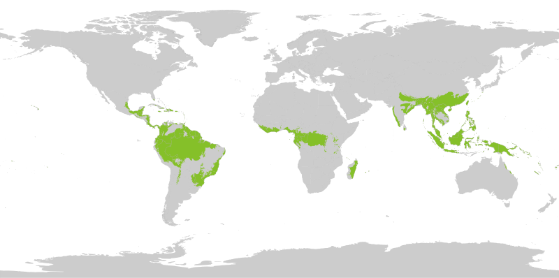
English: Tropical wet forests. The humid tropical biome was delineated using the World Wildlife Fund terrestrial ecoregions map. This map was modified to exclude mountain and coastal forest mosaic ecoregions in Africa.
Français : Forêts tropicales humides. |
| Date | |
| Source | Own work |
| Author | Yerachmiel C |
Licensing
- You are free:
- to share – to copy, distribute and transmit the work
- to remix – to adapt the work
- Under the following conditions:
- attribution – You must give appropriate credit, provide a link to the license, and indicate if changes were made. You may do so in any reasonable manner, but not in any way that suggests the licensor endorses you or your use.
- share alike – If you remix, transform, or build upon the material, you must distribute your contributions under the same or compatible license as the original.
Map uses following sources:
"Biome boundary. The humid tropical biome was delineated using the World Wildlife Fund terrestrial ecoregions map. This map was modified to exclude mountain and coastal forest mosaic ecoregions in Africa." on Global Forest Monitoring Project
Original data licensed as:
"Provided data are available for use for valid scientific, conservation, and educational purposes as long as proper citations are used. We ask that you credit the Humid Tropical Monitoring data as follows: Hansen, M.C., Stehman, S.V., Potapov, P.V., Loveland, T.R., Townshend, J.R.G., DeFries, R.S., Pittman, K.W., Stolle, F., Steininger, M.K., Carroll, M., Dimiceli, C. (2008) Humid tropical forest clearing from 2000 to 2005 quantified using multi-temporal and multi-resolution remotely sensed data. PNAS, 105(27), 9439-9444."
Shapefile of forests:
- By Geographic Information Science Center of Excellence (GIScCE) - SDSU [1] ;
World map with national country outlines and border:
File history
Click on a date/time to view the file as it appeared at that time.
| Date/Time | Thumbnail | Dimensions | User | Comment | |
|---|---|---|---|---|---|
| current | 16:20, 27 August 2022 | | 1,052 × 523 (7.7 MB) | Yerachmiel C | reduce stroke around country borders |
| 16:10, 27 August 2022 |  | 1,052 × 523 (7.76 MB) | Yerachmiel C | fix | |
| 15:17, 27 August 2022 |  | 1,052 × 523 (7.9 MB) | Yerachmiel C | Uploaded own work with UploadWizard |
File usage
Global file usage
The following other wikis use this file:
- Usage on en.wikibooks.org
- Usage on he.wikipedia.org
- Usage on uk.wikipedia.org