
File:TransperthRailwayMap.svg

Size of this PNG preview of this SVG file: 371 × 599 pixels. Other resolutions: 148 × 240 pixels | 297 × 480 pixels | 475 × 768 pixels | 634 × 1,024 pixels | 1,268 × 2,048 pixels | 650 × 1,050 pixels.
Original file (SVG file, nominally 650 × 1,050 pixels, file size: 142 KB)
| This is a file from the Wikimedia Commons. Information from its description page there is shown below. Commons is a freely licensed media file repository. You can help. |

|
This file may be updated to reflect new information. If you wish to use a specific version of the file without new updates being mirrored, please upload the required version as a separate file. |
Summary
| Description |
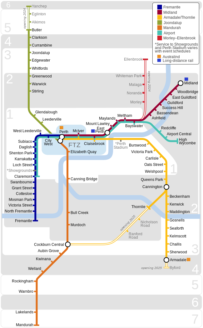
English: A map of the Transperth railway network.
Français : Un plan de réseau chemin de fer de Transperth. |
| Date | |
| Source | Own work |
| Author | DavidArthur |
Licensing
I, DavidArthur, the copyright holder of this work, hereby publishes it under the following licenses:

|
Permission is granted to copy, distribute and/or modify this document under the terms of the GNU Free Documentation License, Version 1.2 or any later version published by the Free Software Foundation; with no Invariant Sections, no Front-Cover Texts, and no Back-Cover Texts. A copy of the license is included in the section entitled GNU Free Documentation License. |
| This file is licensed under the Creative Commons Attribution-Share Alike 3.0 Unported license. | ||
| Attribution: I, DavidArthur | ||
| ||
| This licensing tag was added to this file as part of the GFDL licensing update. |
This file is licensed under the Creative Commons Attribution-Share Alike 2.5 Generic, 2.0 Generic and 1.0 Generic license.
Attribution: I, DavidArthur
- You are free:
- to share – to copy, distribute and transmit the work
- to remix – to adapt the work
- Under the following conditions:
- attribution – You must give appropriate credit, provide a link to the license, and indicate if changes were made. You may do so in any reasonable manner, but not in any way that suggests the licensor endorses you or your use.
- share alike – If you remix, transform, or build upon the material, you must distribute your contributions under the same or compatible license as the original.
You may select the license of your choice.
File history
Click on a date/time to view the file as it appeared at that time.
| Date/Time | Thumbnail | Dimensions | User | Comment | |
|---|---|---|---|---|---|
| current | 02:59, 4 November 2023 | | 650 × 1,050 (142 KB) | Steelkamp | Added opening dates for Yanchep Rail Extension, Morley–Ellenbrook Line, Byford Rail Extension, and Thornlie–Cockburn Link. |
| 15:38, 2 November 2023 |  | 650 × 1,050 (142 KB) | Steelkamp | Changed colour of Morley–Ellenbrook line to red and added line to key. | |
| 15:29, 2 November 2023 |  | 650 × 1,050 (137 KB) | Steelkamp | Lakelands station now open | |
| 13:13, 9 October 2022 |  | 650 × 1,050 (139 KB) | DavidArthur | Airport line open | |
| 16:07, 21 August 2021 |  | 650 × 1,050 (137 KB) | DavidArthur | Updated to 2021 | |
| 14:57, 8 November 2014 |  | 650 × 1,000 (1.01 MB) | DavidArthur | Display fixes | |
| 14:55, 8 November 2014 |  | 650 × 1,000 (1.01 MB) | DavidArthur | Butler extension & airport plans | |
| 23:49, 9 February 2009 |  | 650 × 945 (1.11 MB) | DavidArthur | Work on northern extension apparently no longer in progress | |
| 23:37, 21 December 2007 |  | 650 × 1,000 (319 KB) | DavidArthur | Display fixes | |
| 23:33, 21 December 2007 |  | 650 × 1,000 (310 KB) | DavidArthur | Mandurah line opening shortly |
File usage
The following pages on the English Wikipedia use this file (pages on other projects are not listed):
Global file usage
The following other wikis use this file:
- Usage on de.wikipedia.org
- Usage on de.wikivoyage.org
- Usage on es.wikipedia.org
- Usage on fr.wikipedia.org
- Usage on hu.wikipedia.org
- Usage on nl.wikipedia.org
- Usage on uk.wikipedia.org
- Usage on www.wikidata.org
- Usage on zh.wikipedia.org