
File:Trópico de Cáncer en México - Carretera 83 (Vía Corta) Zaragoza-Victoria, Km 27+800.jpg

Size of this preview: 800 × 600 pixels. Other resolutions: 320 × 240 pixels | 640 × 480 pixels | 1,024 × 768 pixels | 1,280 × 960 pixels | 2,560 × 1,920 pixels | 3,264 × 2,448 pixels.
Original file (3,264 × 2,448 pixels, file size: 2.33 MB, MIME type: image/jpeg)
| This is a file from the Wikimedia Commons. Information from its description page there is shown below. Commons is a freely licensed media file repository. You can help. |
_Zaragoza-Victoria,_Km_27%2B800.jpg)
Summary
| Description |
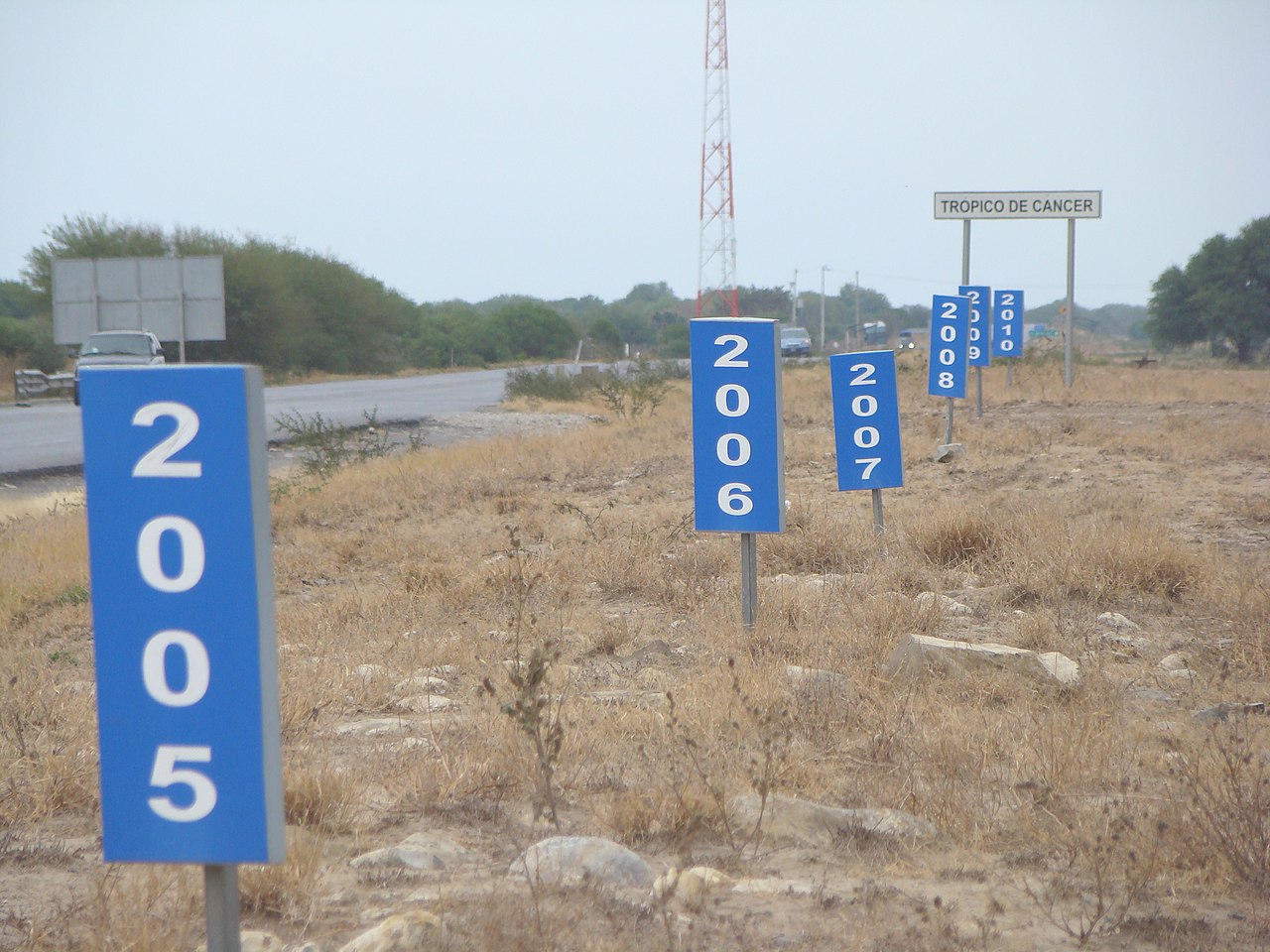
Español: De todos los cruces del Trópico de Cáncer con las carreteras federales mexicanas, éste es el único lugar donde la línea está marcada con absoluta precisión y además se puede visualizar el desplazamiento anual entre los años 2005 y 2010.
English: Of all crossings of the Tropic of Cancer with Mexican federal highways, this is the only place where the line is marked with precision and history of the annual movement since 2005.
Publicada originalmente en Trópico en movimiento (Archived 22 May 2011 at the Wayback Machine) |
| Date | |
| Source | Own work |
| Author | Roberto González |
Licensing
I, the copyright holder of this work, hereby publish it under the following licenses:

|
Permission is granted to copy, distribute and/or modify this document under the terms of the GNU Free Documentation License, Version 1.2 or any later version published by the Free Software Foundation; with no Invariant Sections, no Front-Cover Texts, and no Back-Cover Texts. A copy of the license is included in the section entitled GNU Free Documentation License. |
This file is licensed under the Creative Commons Attribution-Share Alike 4.0 International, 3.0 Unported, 2.5 Generic, 2.0 Generic and 1.0 Generic license.
- You are free:
- to share – to copy, distribute and transmit the work
- to remix – to adapt the work
- Under the following conditions:
- attribution – You must give appropriate credit, provide a link to the license, and indicate if changes were made. You may do so in any reasonable manner, but not in any way that suggests the licensor endorses you or your use.
- share alike – If you remix, transform, or build upon the material, you must distribute your contributions under the same or compatible license as the original.
You may select the license of your choice.
File history
Click on a date/time to view the file as it appeared at that time.
| Date/Time | Thumbnail | Dimensions | User | Comment | |
|---|---|---|---|---|---|
| current | 04:47, 1 February 2011 | | 3,264 × 2,448 (2.33 MB) | Wkboonec | {{Information |Description ={{es|1=De todos los cruces del Trópico de Cáncer con las carreteras federales mexicanas, éste es el único lugar donde la imaginaria línea está marcada con absoluta precisión y además se puede visualizar el desplazami |
File usage
The following pages on the English Wikipedia use this file (pages on other projects are not listed):
Global file usage
The following other wikis use this file:
- Usage on ast.wikipedia.org
- Usage on ba.wikipedia.org
- Usage on bh.wikipedia.org
- Usage on bs.wikipedia.org
- Usage on ca.wikipedia.org
- Usage on de.wikipedia.org
- Usage on es.wikipedia.org
- Usage on he.wikipedia.org
- Usage on ilo.wikipedia.org
- Usage on it.wikipedia.org
- Usage on ja.wikipedia.org
- Usage on mk.wikipedia.org
- Usage on ml.wikipedia.org
- Usage on ms.wikipedia.org
- Usage on no.wikipedia.org
- Usage on pl.wikipedia.org
- Usage on rue.wikipedia.org
- Usage on ru.wikipedia.org
- Usage on sr.wikipedia.org
- Usage on sv.wikipedia.org
- Usage on ta.wikipedia.org
- Usage on tr.wikipedia.org
- Usage on www.wikidata.org
_Zaragoza-Victoria,_Km_27%2B800.jpg)