
File:Torre Faro lighthouse - Capo Peloro - Messina, Italy - 20 Oct. 2010.jpg

Size of this preview: 800 × 531 pixels. Other resolutions: 320 × 213 pixels | 640 × 425 pixels | 1,024 × 680 pixels | 1,280 × 850 pixels | 2,560 × 1,700 pixels | 4,288 × 2,848 pixels.
Original file (4,288 × 2,848 pixels, file size: 7.98 MB, MIME type: image/jpeg)
| This is a file from the Wikimedia Commons. Information from its description page there is shown below. Commons is a freely licensed media file repository. You can help. |
Summary
| Description |
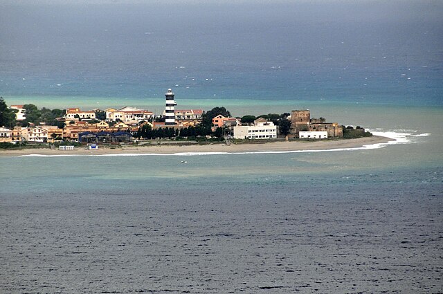
My photos are FREE for anyone to use, just give me credit and it would be nice if you let me know. Thanks This lighthouse was built in 1884, it is 37m (121ft) high, it use to be 42m (138ft). It was shortened after it was damaged after a earthquake and tsunami in 1908, which destroyed 90% of the buildings in Messina and killed more than 100,000 people. It is a octagonal masonry tower with lantern and gallery, rising from a one story masonry keeper's house. This lighthouse marks the extreme northeastern tip of Sicily and the west side entrance to the Strait of Messina from the Tyrrhenian Sea. |
| Date | |
| Source | DGJ_2844 - Capo Peloro Lighthouse |
| Author | Dennis Jarvis from Halifax, Canada |
| Camera location | | View this and other nearby images on: OpenStreetMap |
|---|
Licensing
This file is licensed under the Creative Commons Attribution-Share Alike 2.0 Generic license.
- You are free:
- to share – to copy, distribute and transmit the work
- to remix – to adapt the work
- Under the following conditions:
- attribution – You must give appropriate credit, provide a link to the license, and indicate if changes were made. You may do so in any reasonable manner, but not in any way that suggests the licensor endorses you or your use.
- share alike – If you remix, transform, or build upon the material, you must distribute your contributions under the same or compatible license as the original.
| This image was originally posted to Flickr by archer10 (Dennis) SLOW at https://www.flickr.com/photos/22490717@N02/5354926339. It was reviewed on 6 February 2012 by FlickreviewR and was confirmed to be licensed under the terms of the cc-by-sa-2.0. |
File history
Click on a date/time to view the file as it appeared at that time.
| Date/Time | Thumbnail | Dimensions | User | Comment | |
|---|---|---|---|---|---|
| current | 15:42, 6 February 2012 | | 4,288 × 2,848 (7.98 MB) | Jacopo Werther | {{Information |Description=My photos are FREE for anyone to use, just give me credit and it would be nice if you let me know. Thanks This lighthouse was built in 1884, it is 37m (121ft) high, it use to be 42m (138ft). It was shortened after it was damage |
File usage
The following pages on the English Wikipedia use this file (pages on other projects are not listed):
Global file usage
The following other wikis use this file:
- Usage on fr.wikipedia.org
- Usage on it.wikipedia.org
- Usage on it.wikivoyage.org
- Usage on nl.wikipedia.org
- Usage on www.wikidata.org