
File:Topographia farbig.jpg
Size of this preview: 765 × 600 pixels. Other resolutions: 306 × 240 pixels | 612 × 480 pixels | 980 × 768 pixels | 1,280 × 1,004 pixels | 2,000 × 1,568 pixels.
Original file (2,000 × 1,568 pixels, file size: 2.12 MB, MIME type: image/jpeg)
| This is a file from the Wikimedia Commons. Information from its description page there is shown below. Commons is a freely licensed media file repository. You can help. |
| Description |
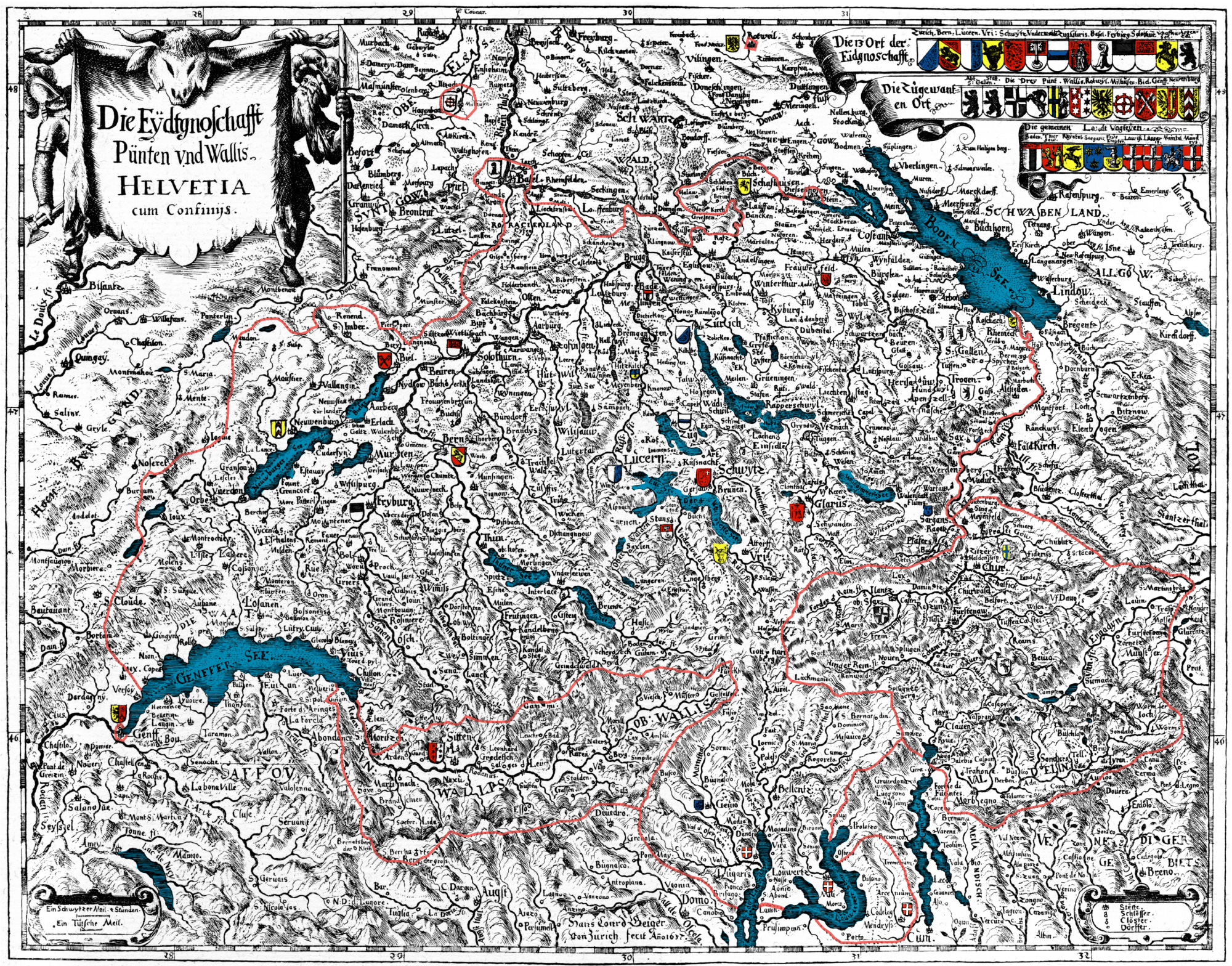
Deutsch: Karte der Alten Eidgenossenschaft 1637. Orginaltitel: "Die Eydtgnoschafft, Pünten und Wallis, Helvetia cum Confiniis". Nachträglich eingefärbt die Grenzen der Alten Eidgenossenschaft, des Wallis und der Drei Bünde sowie die Wappen English: Map of the Old Swiss Confederacy of the year 1637. Original caption: "Die Eydtgnoschafft Pünten und Wallis, Helvetia cum Confiniis" – "The Confederacy, the Leagues and Wallis, Switzerland and neighbouring areas". The borderlines of the Old Confederacy, Wallis and the Three Leagues as well as the coat of arms are not originally coloured |
|
| Date | ||
| Source | Matthäus Merian: Topgraphia Helvetiae, Rhaetiae, et Valesiae. Beschreibung unnd eygentliche Abbildung der vornehmsten Staette und Plaetze in der Hochloeblichen Eydgnossschaft, Graubuenden, Wallis, und etlicher zugewandten Orthen. Franckfurt am Mayn, MDCLIV. | |
| Author | Hans Conrad Geiger; colours Marco Zanoli, (sidonius 20:53, 30 September 2006 (UTC)) | |
| Permission (Reusing this file) |
|
|
| Other versions |
 |
I, the copyright holder of this work, hereby publish it under the following license:
This file is licensed under the Creative Commons Attribution-Share Alike 2.5 Generic license.
- You are free:
- to share – to copy, distribute and transmit the work
- to remix – to adapt the work
- Under the following conditions:
- attribution – You must give appropriate credit, provide a link to the license, and indicate if changes were made. You may do so in any reasonable manner, but not in any way that suggests the licensor endorses you or your use.
- share alike – If you remix, transform, or build upon the material, you must distribute your contributions under the same or compatible license as the original.
File history
Click on a date/time to view the file as it appeared at that time.
| Date/Time | Thumbnail | Dimensions | User | Comment | |
|---|---|---|---|---|---|
| current | 20:53, 30 September 2006 | | 2,000 × 1,568 (2.12 MB) | Sidonius | == Beschreibung == {{Information |Description=''de:''Karte der Alten Eidgenossenschaft 1637. Orginaltitel: "Die Eydtgnoschafft, Pünten und Wallis, Helvetia cum Confiniis". Nachträglich eingefärbt die Grenzen der Alten Ei |
File usage
The following pages on the English Wikipedia use this file (pages on other projects are not listed):