
File:Tidmington House - geograph.org.uk - 509722 (cropped).jpg
No higher resolution available.
Tidmington_House_-_geograph.org.uk_-_509722_(cropped).jpg (389 × 259 pixels, file size: 71 KB, MIME type: image/jpeg)
| This is a file from the Wikimedia Commons. Information from its description page there is shown below. Commons is a freely licensed media file repository. You can help. |
Summary
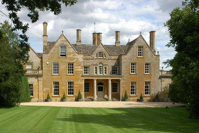
This is a photo of listed building number 1253800. |
| Description |
English: Tidmington House Tidmington House stands overlooking the River Stour beside the A3400 to the south of Shipston-on-Stour. Pevsner describes the house as dating from around 1600 with a mid-18th-century front. Extracted from File:Tidmington House - geograph.org.uk - 509722.jpg |
| Date | |
| Source |
This file was derived from: Tidmington House - geograph.org.uk - 509722.jpg |
| Author | Philip Halling |
| Other versions | |
| Attribution (required by the license) | Philip Halling / Tidmington House / |

.jpg)
| Camera location | | View this and other nearby images on: OpenStreetMap |
|---|
.jpg¶ms=052.045230_N_-001.620800_E_globe:Earth_type:camera_source:geograph-osgb36(SP26103860)_heading:90.00&language=en)
| Object location | | View this and other nearby images on: OpenStreetMap |
|---|
.jpg¶ms=052.045230_N_-001.619600_E_globe:Earth_class:object_type:object_source:geograph-osgb36(SP26183860)_heading:90.00&language=en)
Licensing
This file is licensed under the Creative Commons Attribution-Share Alike 2.0 Generic license.
Attribution: Philip Halling
- You are free:
- to share – to copy, distribute and transmit the work
- to remix – to adapt the work
- Under the following conditions:
- attribution – You must give appropriate credit, provide a link to the license, and indicate if changes were made. You may do so in any reasonable manner, but not in any way that suggests the licensor endorses you or your use.
- share alike – If you remix, transform, or build upon the material, you must distribute your contributions under the same or compatible license as the original.
File history
Click on a date/time to view the file as it appeared at that time.
| Date/Time | Thumbnail | Dimensions | User | Comment | |
|---|---|---|---|---|---|
| current | 16:46, 24 March 2019 | | 389 × 259 (71 KB) | Acabashi | File:Tidmington House - geograph.org.uk - 509722.jpg cropped 39 % horizontally, 39 % vertically using CropTool with precise mode. Cropped for new article. |
File usage
The following pages on the English Wikipedia use this file (pages on other projects are not listed):
.jpg)