
File:The chalk pit - geograph.org.uk - 1772210.jpg
No higher resolution available.
The_chalk_pit_-_geograph.org.uk_-_1772210.jpg (640 × 544 pixels, file size: 98 KB, MIME type: image/jpeg)
| This is a file from the Wikimedia Commons. Information from its description page there is shown below. Commons is a freely licensed media file repository. You can help. |
Summary
| Description |
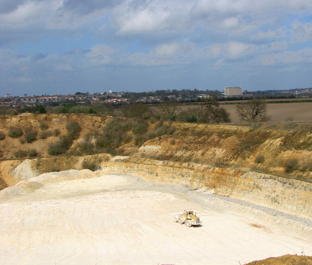
English: The chalk pit This gravel pit is situated north-west of the village of Arminghall. The city of Norwich can be seen in the distance, the large square building at right is County Hall. This view was taken from Boudica's Way which leads past here.
The chalk pit by Caistor St Edmund is a working quarry located 4 kilometres south of Norwich. Formerly exploited mainly for chalk, the operations have moved towards an area where the overlying sands and gravel beds are being worked at the expense of the chalk. The pit is the last remaining well-exposed inland section of part of the Beeston Chalk Formation of the Upper Campanian 'Norwich Chalk' and it is also the last inland section of any size in the Upper Campanian succession of the Transitional Province. It is rich in macrofossils and well-preserved microfaunas. Boudica's Way is a 40-mile footpath that links Norwich and the market town of Diss on the Suffolk borders. The name Boudica (often spelled 'Boadicea', which was the Victorian version or 'Boudicca', used by Tacitus) derives from the Celtic 'bouda' which means victory. Boudica was the wife of the Icenian king Prasutagus. When he died his kingdom was annexed by the Romans, Boudica was flogged and her daughters raped. In AD 60 or 61 Boudica led the Iceni, along with others, in revolt. They destroyed Camulodunum (Colchester) and the site of a temple to the former emperor Claudius. Boudica was defeated in the end and is reported by Tacitus to have poisoned herself. The site where she is buried is unknown. |
| Date | |
| Source | From geograph.org.uk |
| Author | Evelyn Simak |
| Attribution (required by the license) | Evelyn Simak / The chalk pit / |
| Camera location | | View this and other nearby images on: OpenStreetMap |
|---|
_heading:0.00&language=en)
| Object location | | View this and other nearby images on: OpenStreetMap |
|---|
_heading:0.00&language=en)
Licensing

|
This image was taken from the Geograph project collection. See this photograph's page on the Geograph website for the photographer's contact details. The copyright on this image is owned by Evelyn Simak and is licensed for reuse under the Creative Commons Attribution-ShareAlike 2.0 license.
|
This file is licensed under the Creative Commons Attribution-Share Alike 2.0 Generic license.
Attribution: Evelyn Simak
- You are free:
- to share – to copy, distribute and transmit the work
- to remix – to adapt the work
- Under the following conditions:
- attribution – You must give appropriate credit, provide a link to the license, and indicate if changes were made. You may do so in any reasonable manner, but not in any way that suggests the licensor endorses you or your use.
- share alike – If you remix, transform, or build upon the material, you must distribute your contributions under the same or compatible license as the original.
File history
Click on a date/time to view the file as it appeared at that time.
| Date/Time | Thumbnail | Dimensions | User | Comment | |
|---|---|---|---|---|---|
| current | 13:51, 14 March 2011 | | 640 × 544 (98 KB) | GeographBot | == {{int:filedesc}} == {{Information |description={{en|1=The chalk pit This gravel pit is situated north-west of the village of Arminghall. The city of Norwich can be seen in the distance, the large square building at right is County Hall. This view was t |
File usage
The following pages on the English Wikipedia use this file (pages on other projects are not listed):