
File:The Monumental Gate, built in the 2nd century AD during the time of Emperor Hadrian, Tyre, Lebanon (48930401736).jpg

Size of this preview: 800 × 530 pixels. Other resolutions: 320 × 212 pixels | 640 × 424 pixels | 1,024 × 678 pixels | 1,280 × 848 pixels | 2,560 × 1,696 pixels | 4,928 × 3,264 pixels.
Original file (4,928 × 3,264 pixels, file size: 11.33 MB, MIME type: image/jpeg)
| This is a file from the Wikimedia Commons. Information from its description page there is shown below. Commons is a freely licensed media file repository. You can help. |
.jpg)
Summary
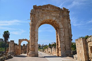
| Description | Destroyed by an earthquake around the 6th century AD, this gate was constructed with sandstone blocks during the 2nd century AD. It was covered with decorated lime plaster which is still showing on some of its stones. The 20-metre high central section has been reconstructed; it was preserved to its middle height when it was first discovered. |
| Date | |
| Source | The Monumental Gate, built in the 2nd century AD during the time of Emperor Hadrian, Tyre, Lebanon |
| Author | Carole Raddato from FRANKFURT, Germany |
| Camera location | | View this and other nearby images on: OpenStreetMap |
|---|
.jpg¶ms=033.271336_N_0035.193275_E_globe:Earth_type:camera_source:Flickr_&language=en)
Licensing
This file is licensed under the Creative Commons Attribution-Share Alike 2.0 Generic license.
- You are free:
- to share – to copy, distribute and transmit the work
- to remix – to adapt the work
- Under the following conditions:
- attribution – You must give appropriate credit, provide a link to the license, and indicate if changes were made. You may do so in any reasonable manner, but not in any way that suggests the licensor endorses you or your use.
- share alike – If you remix, transform, or build upon the material, you must distribute your contributions under the same or compatible license as the original.
| This image was originally posted to Flickr by Following Hadrian at https://flickr.com/photos/41523983@N08/48930401736. It was reviewed on 29 January 2021 by FlickreviewR 2 and was confirmed to be licensed under the terms of the cc-by-sa-2.0. |
File history
Click on a date/time to view the file as it appeared at that time.
| Date/Time | Thumbnail | Dimensions | User | Comment | |
|---|---|---|---|---|---|
| current | 13:03, 29 January 2021 | | 4,928 × 3,264 (11.33 MB) | Frombowen | Transferred from Flickr via #flickr2commons |
File usage
No pages on the English Wikipedia use this file (pages on other projects are not listed).
Global file usage
The following other wikis use this file:
.jpg)