
File:Texas Park Road 4 CCC Map 1 edit.jpg

Size of this preview: 800 × 108 pixels. Other resolutions: 320 × 43 pixels | 640 × 86 pixels | 1,024 × 138 pixels | 1,280 × 173 pixels | 8,191 × 1,104 pixels.
Original file (8,191 × 1,104 pixels, file size: 3.55 MB, MIME type: image/jpeg)
| This is a file from the Wikimedia Commons. Information from its description page there is shown below. Commons is a freely licensed media file repository. You can help. |
Summary
| Description |
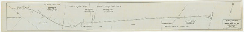
English: A plan for the routing of what would become a section of Texas Park Road 4. Drawn by the Civilian Conservation Corps, 1934. Warmed by uploader in Lightroom (+30) |
| Date | |
| Source | File:Texas Park Road 4 CCC Map 1.png |
| Author | Civilian Conservation Corps |
Licensing
This work is in the public domain in the United States because it is a work prepared by an officer or employee of the United States Government as part of that person’s official duties under the terms of Title 17, Chapter 1, Section 105 of the US Code.
Note: This only applies to original works of the Federal Government and not to the work of any individual U.S. state, territory, commonwealth, county, municipality, or any other subdivision. This template also does not apply to postage stamp designs published by the United States Postal Service since 1978. (See § 313.6(C)(1) of Compendium of U.S. Copyright Office Practices). It also does not apply to certain US coins; see The US Mint Terms of Use.
|
 | |
| This file has been identified as being free of known restrictions under copyright law, including all related and neighboring rights. | ||
This file is in the public domain because The Texas State Library states that: "The Civilian Conservation Corps drawings posted on the Commons are the results of the work of the architects, engineers and draftsmen employed by the Corps, a federally funded New Deal program. There are no known copyright restrictions associated with these drawings." (From here)
|
File history
Click on a date/time to view the file as it appeared at that time.
| Date/Time | Thumbnail | Dimensions | User | Comment | |
|---|---|---|---|---|---|
| current | 03:06, 26 March 2014 | 8,191 × 1,104 (3.55 MB) | A Texas Historian | Minor restoration work: remove the two major creases (stitching errors?) from the scan, work with orange spots, remove some dirt from one area. | |
| 02:25, 16 March 2014 | 8,191 × 1,104 (2.7 MB) | Crisco 1492 | Color edit again | ||
| 23:27, 14 March 2014 | 8,191 × 1,104 (2.53 MB) | Crisco 1492 | =={{int:filedesc}}== {{Information |description={{en|1=A plan for the routing of what would become a section of Texas Park Road 4. Drawn by the Civilian Conservation Corps, 1934. Warmed by uploader in Lightroom (+30)}} |date=1934-10-25 |source=[[:File:... |
File usage
The following pages on the English Wikipedia use this file (pages on other projects are not listed):
- Civilian Conservation Corps
- Texas Park Road 4
- Transportation planning
- Wikipedia:Featured picture candidates/April-2014
- Wikipedia:Featured picture candidates/March-2014
- Wikipedia:Featured picture candidates/Texas Highway Planning Map
- Wikipedia:Featured picture candidates/Texas Road Planning Map renom
Global file usage
The following other wikis use this file:
- Usage on bn.wikipedia.org
- Usage on ca.wikipedia.org
- Usage on fa.wikipedia.org