
File:Teideform2.png

Size of this preview: 504 × 600 pixels. Other resolutions: 202 × 240 pixels | 588 × 700 pixels.
Original file (588 × 700 pixels, file size: 58 KB, MIME type: image/png)
| This is a file from the Wikimedia Commons. Information from its description page there is shown below. Commons is a freely licensed media file repository. You can help. |
Summary
| Description |
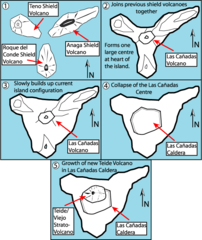
English: This is a very schematic diagram of the formation of the island of Tenerife and evolution of the current Teide volcano. In step one the island began as three separate shield volcanoes - Anaga to the NE, Teno to the NW and Roque del Conde to the south. Step Two: After a period of erosion of the older massifs a new period of volcanic activity saw the creation of the large Las Canadas volcano. Step Three: The islands current shape begins to become apparent as Las Canadas grew. Step Four: The Las Canadas edifice collapsed to form the Las Canadas Caldera into which Step Five: The current Teide/Vierjo Central complex has grown within this collapsed Las Canadas Caldera (more detailed/smaller of two versions). |
| Date | 09/10/07 |
| Source | Own work |
| Author | Fossiliferous |
Licensing
I, the copyright holder of this work, hereby publish it under the following licenses:

|
Permission is granted to copy, distribute and/or modify this document under the terms of the GNU Free Documentation License, Version 1.2 or any later version published by the Free Software Foundation; with no Invariant Sections, no Front-Cover Texts, and no Back-Cover Texts. A copy of the license is included in the section entitled GNU Free Documentation License. |
This file is licensed under the Creative Commons Attribution 3.0 Unported license.
- You are free:
- to share – to copy, distribute and transmit the work
- to remix – to adapt the work
- Under the following conditions:
- attribution – You must give appropriate credit, provide a link to the license, and indicate if changes were made. You may do so in any reasonable manner, but not in any way that suggests the licensor endorses you or your use.
You may select the license of your choice.
File history
Click on a date/time to view the file as it appeared at that time.
| Date/Time | Thumbnail | Dimensions | User | Comment | |
|---|---|---|---|---|---|
| current | 09:01, 1 February 2008 | | 588 × 700 (58 KB) | Xiong Chiamiov | optimized using optipng |
| 14:18, 9 October 2007 |  | 588 × 700 (96 KB) | ExtraFossiliferous | This is a very schematic diagram of the formation of the island of Tenerife and evolution of the current Teide volcano. In step one the island began as three separate shield volcanoes - Anaga to the NE, Teno to the NW and Roque del Conde to the south. Ste | |
| 14:12, 9 October 2007 |  | 588 × 700 (96 KB) | ExtraFossiliferous | {{Information |Description=This is a very schematic diagram of the formation of the island of Tenerife and evolution of the current Teide volcano. In step one the island began as three separate shield volcanoes - Anaga to the NE, Teno to the NW and Roque |
File usage
The following pages on the English Wikipedia use this file (pages on other projects are not listed):
Global file usage
The following other wikis use this file: