
File:TDWR and NEXRAD Refl Compared vert.png

Size of this preview: 323 × 599 pixels. Other resolutions: 129 × 240 pixels | 476 × 883 pixels.
Original file (476 × 883 pixels, file size: 152 KB, MIME type: image/png)
| This is a file from the Wikimedia Commons. Information from its description page there is shown below. Commons is a freely licensed media file repository. You can help. |
Summary
| Description |
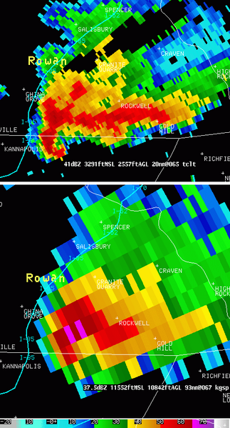
English: Radar reflectivity at 0.5 degree scan from the KGSP WSR-88D (NEXRAD) at 1844 UTC (right) and Radar reflectivity at 1.0 degree scan from the TCLT TDWR, colocated, at 1842 UTC on left. One can notice easily the improved resolution on the TDWR but the attenuation region caused by the heavy precipitations when compared to NEXRAD data |
| Date | |
| Source | http://www.erh.noaa.gov/gsp/tdwr/info/specs.html |
| Author | National Weather Service of the United States |
| Permission (Reusing this file) |
Public domain. |
Licensing
This image is in the public domain because it contains materials that originally came from the U.S. National Oceanic and Atmospheric Administration, taken or made as part of an employee's official duties.
|
File history
Click on a date/time to view the file as it appeared at that time.
| Date/Time | Thumbnail | Dimensions | User | Comment | |
|---|---|---|---|---|---|
| current | 05:26, 2 October 2009 | | 476 × 883 (152 KB) | Tachymètre | == {{int:filedesc}} == {{Information |Description={{en|1=Radar reflectivity at 0.5 degree scan from the KGSP WSR-88D (NEXRAD) at 1844 UTC (right) and Radar reflectivity at 1.0 degree scan from the TCLT TDWR, colocated, at 1842 UTC on left. One can notice |
File usage
The following pages on the English Wikipedia use this file (pages on other projects are not listed):
Global file usage
The following other wikis use this file:
- Usage on es.wikipedia.org
- Usage on fr.wikipedia.org
- Usage on www.wikidata.org