
File:Strong-Mine-Handling.jpg
Strong-Mine-Handling.jpg (662 × 464 pixels, file size: 64 KB, MIME type: image/jpeg)
| This is a file from the Wikimedia Commons. Information from its description page there is shown below. Commons is a freely licensed media file repository. You can help. |
Summary
| Description |
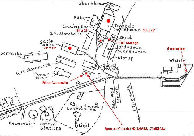
English: This plan of the mine-handling facilities at Fort Strong comes from the U.S. Army Engineers' Reports of Completed Works (RCWs) for Fort Strong, Long Island, Boston Harbor, and is indicated as being updated through October, 1921. The notes in red have been added for use on Wikipedia, with building dimensions obtained from other RCWs. The coordinates of the center of the mine casemate were observed from Google Maps and are included to index the location of the map. |
| Source | Own work by the original uploader |
| Author |
The tracks running from the wharf through the mine buildings are those of the mine tramway, used to transport the heavy mines to and from the mine laying boats, the mine storehouse, and the loading room (where the mines were filled with TNT). In the 1915-1925 period, the tramway also extended up the slope (at bottom-left) toward the large artillery fortifications on the heights above and was used to haul projectiles and powder to the guns.
The cable tanks were located in an enclosed building and were used to store and test huge reels of electrical cable that connected the mines to their distribution box and also to the mine casemate on shore. These reels were also carried on the tramway. All these mine buildings were equipped with overhead (bridge) cranes, and a fixed-leg crane sat on the wharf for loading the cable laying craft.
The buildings not highlighted in red served other parts of the fort. The fire control stations indicated at bottom served the gun batteries, not the mine casemate. A separate mine base end station (fire control building) was located in a wooden building just off the bottom of this map.
Licensing
This image or file is a work of a U.S. Army Corps of Engineers soldier or employee, taken or made as part of that person's official duties. As a work of the U.S. federal government, the image is in the public domain.
|
Original upload log
Transferred from en.wikipedia to Commons using For the Common Good.
| Date/Time | Dimensions | User | Comment |
|---|---|---|---|
| 20:09, 28 July 2010 | 662 × 464 (65,532 bytes) | w:en:Pgrig (talk | contribs) | This plan of the mine-handling facilities at Fort Strong comes from the U.S. Army Engineers' Reports of Completed Works (RCWs)for Fort Strong, Long Island, Boston Harbor, and is indicated as being updated through October, 1921. The notes in red have been |
File history
Click on a date/time to view the file as it appeared at that time.
| Date/Time | Thumbnail | Dimensions | User | Comment | |
|---|---|---|---|---|---|
| current | 03:36, 8 January 2018 | | 662 × 464 (64 KB) | Illegitimate Barrister | Transferred from en.wikipedia: see original upload log above |