
File:Stift Bremen, Atlas Cosmographicae (Mercator).jpg

Size of this preview: 374 × 599 pixels. Other resolutions: 150 × 240 pixels | 300 × 480 pixels | 479 × 768 pixels | 639 × 1,024 pixels | 1,317 × 2,109 pixels.
Original file (1,317 × 2,109 pixels, file size: 1.75 MB, MIME type: image/jpeg)
| This is a file from the Wikimedia Commons. Information from its description page there is shown below. Commons is a freely licensed media file repository. You can help. |
.jpg)
Summary
| Description |
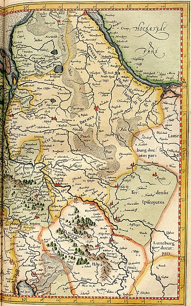
English: Cropping of a plate from Gerardus Mercator's Atlas Cosmographicae (1595) showing the Prince-Archbishopric of Bremen ("Stift Bremen", in yellow) on the west bank of the Elbe River. In the late 16th century when this map was drawn, the Prince-Archbishopric was ruled by Protestants administrators. The Archdiocese of Bremen was much larger while the city of Bremen proper was a self-ruling free imperial city. The Prince-Bishopric of Verden ("Ferdensis Episcopatus", in green) is shown to the southeast of the Prince-Archbishopric of Bremen. |
| Date | |
| Source | Atlas Cosmographicae, etc., Gerardus Mercator |
| Author | Gerardus Mercator |
Licensing
|
This work is in the public domain in its country of origin and other countries and areas where the copyright term is the author's life plus 100 years or fewer. | |
| This file has been identified as being free of known restrictions under copyright law, including all related and neighboring rights. | |
File history
Click on a date/time to view the file as it appeared at that time.
| Date/Time | Thumbnail | Dimensions | User | Comment | |
|---|---|---|---|---|---|
| current | 23:25, 25 January 2021 | | 1,317 × 2,109 (1.75 MB) | Lubiesque | Uploaded a work by Gerardus Mercator from Atlas Sive Cosmographicae, etc., Gerardus Mercator with UploadWizard |
File usage
The following pages on the English Wikipedia use this file (pages on other projects are not listed):
Global file usage
The following other wikis use this file:
- Usage on it.wikipedia.org
.jpg)