
File:St Mary, Weston - geograph.org.uk - 105813.jpg
No higher resolution available.
St_Mary,_Weston_-_geograph.org.uk_-_105813.jpg (640 × 480 pixels, file size: 147 KB, MIME type: image/jpeg)
| This is a file from the Wikimedia Commons. Information from its description page there is shown below. Commons is a freely licensed media file repository. You can help. |
Summary
| Description |
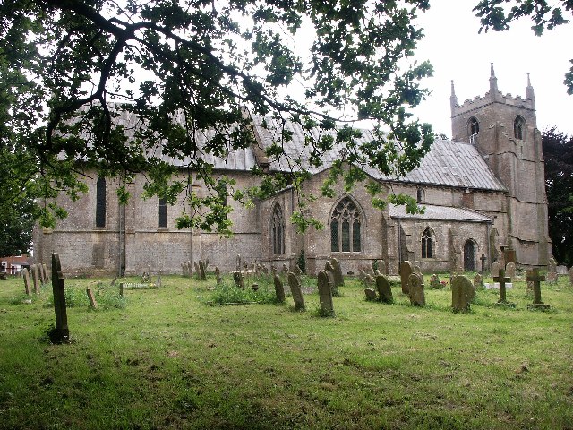
English: St Mary, Weston. A small stone church was built soon after 1154. The only parts of the church that remain are the lower parts of the chancel walls, the stone benches and the little Norman doorway at the south side. The nave of the church of St Mary is dated 1260. The chancel was rebuilt after 1290 and the transepts were added between 1350 and 1360. The massive tower arch soars almost as high as the tower, which was added about 1420. |
| Date | |
| Source | From geograph.org.uk |
| Author | Dave Hitchborne |
| Attribution (required by the license) | Dave Hitchborne / St Mary, Weston / |
| Camera location | | View this and other nearby images on: OpenStreetMap |
|---|
_&language=en)
| Object location | | View this and other nearby images on: OpenStreetMap |
|---|
_&language=en)
Licensing

|
This image was taken from the Geograph project collection. See this photograph's page on the Geograph website for the photographer's contact details. The copyright on this image is owned by Dave Hitchborne and is licensed for reuse under the Creative Commons Attribution-ShareAlike 2.0 license.
|
This file is licensed under the Creative Commons Attribution-Share Alike 2.0 Generic license.
Attribution: Dave Hitchborne
- You are free:
- to share – to copy, distribute and transmit the work
- to remix – to adapt the work
- Under the following conditions:
- attribution – You must give appropriate credit, provide a link to the license, and indicate if changes were made. You may do so in any reasonable manner, but not in any way that suggests the licensor endorses you or your use.
- share alike – If you remix, transform, or build upon the material, you must distribute your contributions under the same or compatible license as the original.
File history
Click on a date/time to view the file as it appeared at that time.
| Date/Time | Thumbnail | Dimensions | User | Comment | |
|---|---|---|---|---|---|
| current | 01:53, 31 January 2010 | | 640 × 480 (147 KB) | GeographBot | == {{int:filedesc}} == {{Information |description={{en|1=St Mary, Weston. A small stone church was built soon after 1154. The only parts of the church that remain are the lower parts of the chancel walls, the stone benches and the little Norman doorway at |
File usage
The following pages on the English Wikipedia use this file (pages on other projects are not listed):
Global file usage
The following other wikis use this file:
- Usage on ceb.wikipedia.org
- Usage on cy.wikipedia.org
- Usage on es.wikipedia.org
- Usage on fr.wikipedia.org
- Usage on it.wikipedia.org
- Usage on lld.wikipedia.org
- Usage on pl.wikipedia.org
- Usage on www.wikidata.org