
File:St Decuman's, Rhoscrowther - geograph.org.uk - 1338416.jpg
No higher resolution available.
St_Decuman's,_Rhoscrowther_-_geograph.org.uk_-_1338416.jpg (640 × 480 pixels, file size: 57 KB, MIME type: image/jpeg)
| This is a file from the Wikimedia Commons. Information from its description page there is shown below. Commons is a freely licensed media file repository. You can help. |
|
This is a photo of listed building number 6591. |
Summary
| Description |
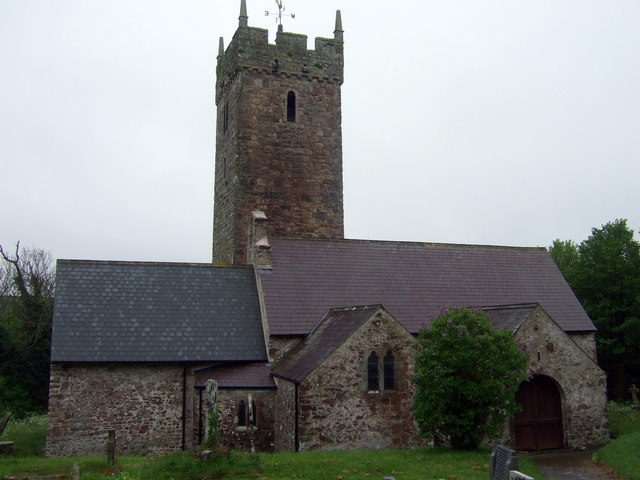
English: St Decuman's, Rhoscrowther A large cruciform mediaeval church which now stands alone, almost the sole survivor of the deserted village of Rhoscrowther.
Supposedly founded by St Decuman(us) or Degman, an early Christian saint who was born here and crossed the Severn in a coracle to Somerset where, in Watchet, is the only other church dedicated to him. It is thought that his cell that once formed part of the church; there is also St Degman's well not far away. The earliest parts of the church go back to C13/14. It was restored twice in the C19 and again in 1910. Services are still held for the exiled villagers. |
| Date | |
| Source | From geograph.org.uk |
| Author | ceridwen |
| Attribution (required by the license) | ceridwen / St Decuman's, Rhoscrowther / |
| Camera location | | View this and other nearby images on: OpenStreetMap |
|---|
_heading:180.00&language=en)
| Object location | | View this and other nearby images on: OpenStreetMap |
|---|
_heading:180.00&language=en)
Licensing

|
This image was taken from the Geograph project collection. See this photograph's page on the Geograph website for the photographer's contact details. The copyright on this image is owned by ceridwen and is licensed for reuse under the Creative Commons Attribution-ShareAlike 2.0 license.
|
This file is licensed under the Creative Commons Attribution-Share Alike 2.0 Generic license.
Attribution: ceridwen
- You are free:
- to share – to copy, distribute and transmit the work
- to remix – to adapt the work
- Under the following conditions:
- attribution – You must give appropriate credit, provide a link to the license, and indicate if changes were made. You may do so in any reasonable manner, but not in any way that suggests the licensor endorses you or your use.
- share alike – If you remix, transform, or build upon the material, you must distribute your contributions under the same or compatible license as the original.
File history
Click on a date/time to view the file as it appeared at that time.
| Date/Time | Thumbnail | Dimensions | User | Comment | |
|---|---|---|---|---|---|
| current | 02:22, 28 February 2011 | | 640 × 480 (57 KB) | GeographBot | == {{int:filedesc}} == {{Information |description={{en|1=St Decuman's, Rhoscrowther A large cruciform mediaeval church which now stands alone, almost the sole suvivor of the deserted village of Rhoscrowther. Supposedly founded by St Decuman(us) or Degman |
File usage
The following pages on the English Wikipedia use this file (pages on other projects are not listed):
Global file usage
The following other wikis use this file:
- Usage on arz.wikipedia.org
- Usage on br.wikipedia.org
- Usage on cy.wikipedia.org
- Usage on www.wikidata.org