
File:St Blaise, Haccombe - geograph.org.uk - 825022.jpg

Original file (480 × 640 pixels, file size: 103 KB, MIME type: image/jpeg)
| This is a file from the Wikimedia Commons. Information from its description page there is shown below. Commons is a freely licensed media file repository. You can help. |
Summary
| Description |
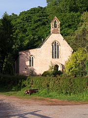
English: St Blaise, Haccombe A singular church, perhaps of as much interest as any other of its size, and possibly dating from 1233, certainly the C13. "The Rector of the church holds the rare title of Archpriest a privilege founded in medieval times and ratified in 1913 by King George V. This entitles him to wear lawn sleeves, like a bishop, and a fur stole, or amyss." (http://www.pbs.org.uk/news/index.asp ) (The more usual spelling would be "amice"). This title reflects the fact that the Archpriest has the right to sit beside the Bishop at ceremonies, and recognises no authority lower than the Archbishop of Canterbury.
The Amice is a rectangle of white linen worn as a neck-cloth or hood with the alb and other vestments at the Eucharist. Not to be confused with the Amyss or Almuce, which is as stated in the preceding paragraph a stole-like garment of animal fur, worn over the surplice by canons, archpriests and other dignitaries in lieu of the Tippet or Black Scarf at Mattins and Evensong. (Note by Hugh Allen, 30 April 2021) Reverend William Keble Martin, the artist of Concise British Flora fame, held the position of Archpriest here from 1921 to 1934. The church was praised by the Prayer Book Society in March 2008 for using only the 1662 Book of Common Prayer. The bell, dating from 1290, may be the oldest in Devon, and there are several remarkable monuments. |
| Date | |
| Source | From geograph.org.uk |
| Author | Derek Harper |
| Attribution (required by the license) | Derek Harper / St Blaise, Haccombe / |
| Camera location | | View this and other nearby images on: OpenStreetMap |
|---|
_heading:67.00&language=en)
| Object location | | View this and other nearby images on: OpenStreetMap |
|---|
_heading:67.00&language=en)
Licensing

|
This image was taken from the Geograph project collection. See this photograph's page on the Geograph website for the photographer's contact details. The copyright on this image is owned by Derek Harper and is licensed for reuse under the Creative Commons Attribution-ShareAlike 2.0 license.
|
- You are free:
- to share – to copy, distribute and transmit the work
- to remix – to adapt the work
- Under the following conditions:
- attribution – You must give appropriate credit, provide a link to the license, and indicate if changes were made. You may do so in any reasonable manner, but not in any way that suggests the licensor endorses you or your use.
- share alike – If you remix, transform, or build upon the material, you must distribute your contributions under the same or compatible license as the original.
File history
Click on a date/time to view the file as it appeared at that time.
| Date/Time | Thumbnail | Dimensions | User | Comment | |
|---|---|---|---|---|---|
| current | 16:57, 20 February 2011 | | 480 × 640 (103 KB) | GeographBot | == {{int:filedesc}} == {{Information |description={{en|1=St Blaise, Haccombe A singular church, perhaps of as much interest as any other of its size, and possibly dating from 1233, certainly the C13. "The Rector of the church holds the rare title of Archp |
File usage
Global file usage
The following other wikis use this file:
- Usage on it.wikipedia.org
- Usage on lld.wikipedia.org
- Usage on pl.wikipedia.org
- Usage on sv.wikipedia.org
- Usage on www.wikidata.org