
File:Srivijaya Empire.svg

Size of this PNG preview of this SVG file: 468 × 476 pixels. Other resolutions: 236 × 240 pixels | 472 × 480 pixels | 755 × 768 pixels | 1,007 × 1,024 pixels | 2,014 × 2,048 pixels.
Original file (SVG file, nominally 468 × 476 pixels, file size: 336 KB)
| This is a file from the Wikimedia Commons. Information from its description page there is shown below. Commons is a freely licensed media file repository. You can help. |
Summary
| Description |
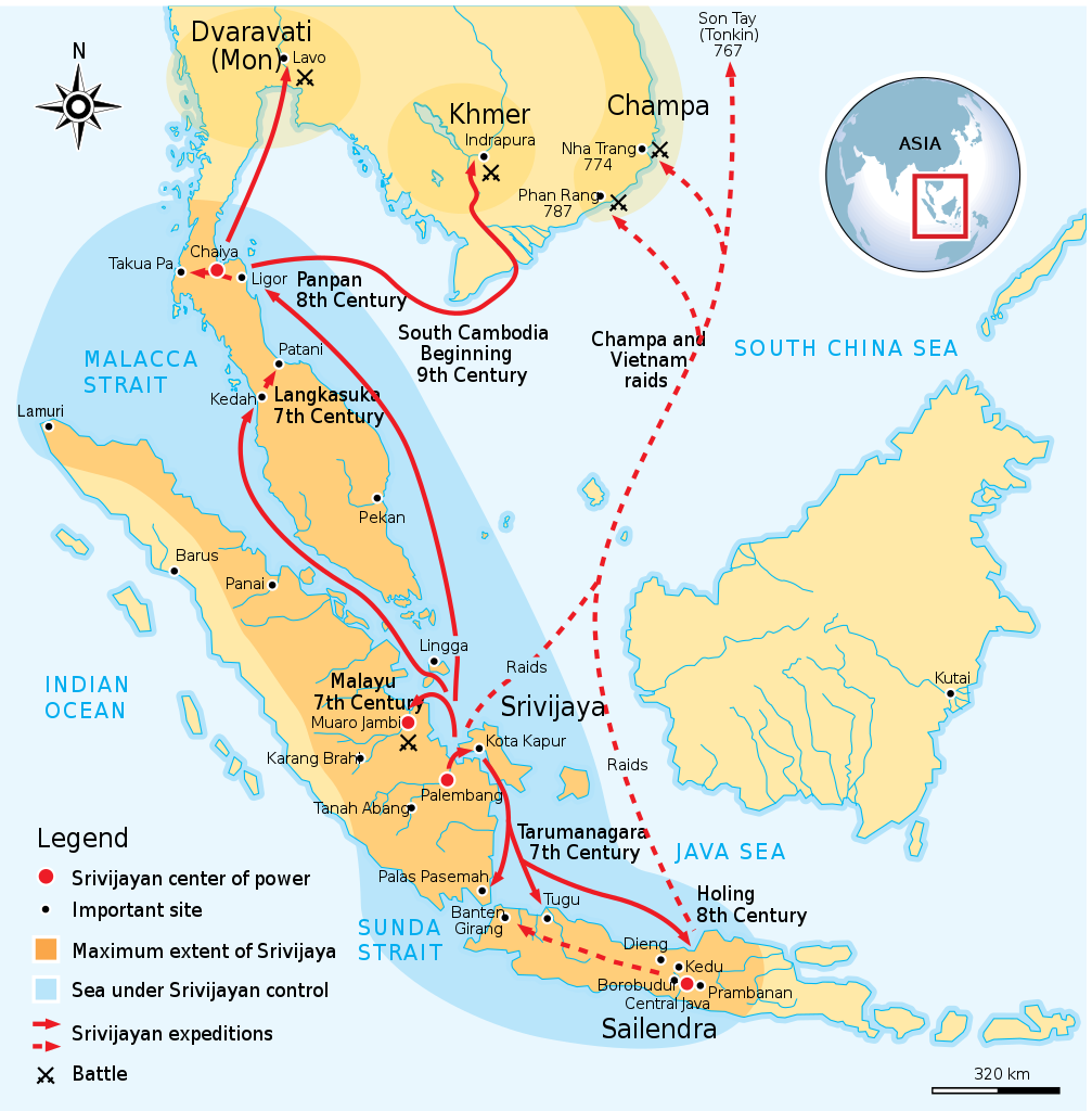
English: Maximum extent of Srivijaya Empire around 8th century. Expanding from Sumatra, Central Java, to Malay Peninsula. The red arrows show the series of Srivijayan expedition and conquest, in diplomatic alliances, military campaign, or naval raids. |
||
| Date | |||
| Source | Own work by uploader,redrawed from Munoz "Early Kingdoms of the Indonesian Archipelago and the Malay Peninsula" page 128 | ||
| Author | Gunawan Kartapranata | ||
| Permission (Reusing this file) |
I, the copyright holder of this work, hereby publish it under the following licenses: This file is licensed under the Creative Commons Attribution-Share Alike 3.0 Unported license.
You may select the license of your choice. |
||
| Other versions |
[]
|


|
This SVG file contains embedded text that can be translated into your language, using any capable SVG editor, text editor or the SVG Translate tool. For more information see: About translating SVG files. |
References
Resources used to create the map:
- Munoz, Paul Michel (2006) Early Kingdoms of the Indonesian Archipelago and the Malay Peninsula, Singapore: Editions Didier Millet, pp. 128, 141 ISBN: 9814155675.
File history
Click on a date/time to view the file as it appeared at that time.
| Date/Time | Thumbnail | Dimensions | User | Comment | |
|---|---|---|---|---|---|
| current | 22:41, 3 December 2014 | | 468 × 476 (336 KB) | Pratyeka | Reposition 'Malacca Straight' label for improved clarity. |
| 22:33, 3 December 2014 |  | 468 × 476 (336 KB) | Pratyeka | Addition of Lamuri, an important point in northwestern Sumatra identified as contemporary and whose location at Lhok Lambaro is reasoned by E. Edwards McKinnon in ''[http://www.scribd.com/doc/8410125/A-note-of-Lamuri-Lambri-Sumatra-Straits-of-Melaka-Ma... | |
| 19:15, 26 August 2009 |  | 468 × 476 (288 KB) | Gunkarta | {{Information |Description={{en|1=Maximum extent of Srivijaya Empire around 8th century. Expanding from Sumatra, Central Java, to Malay Peninsula. The red arrows show the series of Srivijayan expedition and conquest, in diplomatic alliances, military camp |
File usage
The following pages on the English Wikipedia use this file (pages on other projects are not listed):
Global file usage
The following other wikis use this file:
- Usage on azb.wikipedia.org
- Usage on ba.wikipedia.org
- Usage on be.wikipedia.org
- Usage on bg.wikipedia.org
- Usage on bn.wikipedia.org
- Usage on ca.wikipedia.org
- Usage on cs.wikipedia.org
- Usage on da.wikipedia.org
- Usage on eo.wikipedia.org
- Usage on fa.wikipedia.org
- Usage on fi.wikibooks.org
- Usage on ha.wikipedia.org
- Usage on hi.wikipedia.org
- Usage on hu.wikipedia.org
- Usage on hy.wikipedia.org
- Usage on id.wikipedia.org
- Usage on io.wikipedia.org
- Usage on it.wikipedia.org
- Usage on ja.wikipedia.org
- Usage on ja.wikibooks.org
- Usage on ka.wikipedia.org
- Usage on km.wikipedia.org
- Usage on ko.wikipedia.org
- Usage on lt.wikipedia.org
- Usage on lv.wikipedia.org
- Usage on min.wikipedia.org
- Usage on ml.wikipedia.org
- Usage on mr.wikipedia.org
- Usage on ms.wikipedia.org
- Usage on mzn.wikipedia.org
- Usage on ne.wikipedia.org
- Usage on no.wikipedia.org
- Usage on pl.wikipedia.org
- Usage on pnb.wikipedia.org
- Usage on ru.wikipedia.org
View more global usage of this file.