
File:Spain Andalusia location map.svg

Size of this PNG preview of this SVG file: 512 × 345 pixels. Other resolutions: 320 × 216 pixels | 640 × 431 pixels | 1,024 × 690 pixels | 1,280 × 863 pixels | 2,560 × 1,725 pixels.
Original file (SVG file, nominally 512 × 345 pixels, file size: 1.22 MB)
| This is a file from the Wikimedia Commons. Information from its description page there is shown below. Commons is a freely licensed media file repository. You can help. |
Summary
| Description |
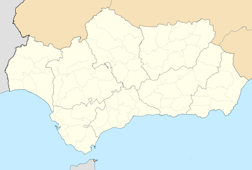
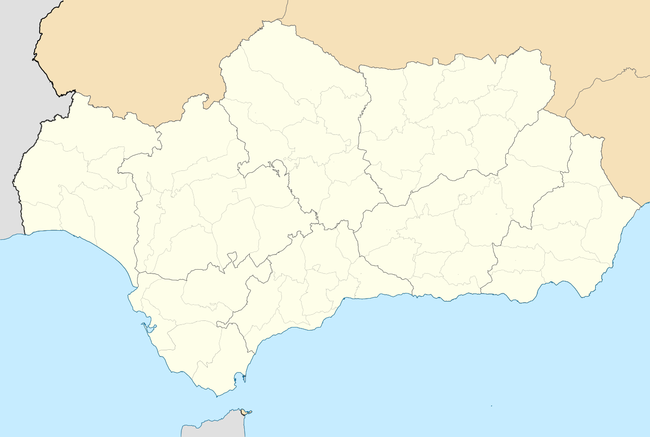
English: Location map of Andalusia
Equirectangular projection, N/S stretching 130 %. Geographic limits of the map:
Español: Mapa de localización de Andalucía
Proyección equirrectangular, N/S estirada 130 %. Límites geográficos del mapa:
|
|
| Date | ||
| Source | Own work based on: EspañaLoc.svg by HansenBCN | |
| Author | Miguillen | |
| SVG development | This locator map was created with Inkscape.
|
Licensing
I, the copyright holder of this work, hereby publish it under the following licenses:

|
Permission is granted to copy, distribute and/or modify this document under the terms of the GNU Free Documentation License, Version 1.2 or any later version published by the Free Software Foundation; with no Invariant Sections, no Front-Cover Texts, and no Back-Cover Texts. A copy of the license is included in the section entitled GNU Free Documentation License. |
This file is licensed under the Creative Commons Attribution-Share Alike 4.0 International, 3.0 Unported, 2.5 Generic, 2.0 Generic and 1.0 Generic license.
- You are free:
- to share – to copy, distribute and transmit the work
- to remix – to adapt the work
- Under the following conditions:
- attribution – You must give appropriate credit, provide a link to the license, and indicate if changes were made. You may do so in any reasonable manner, but not in any way that suggests the licensor endorses you or your use.
- share alike – If you remix, transform, or build upon the material, you must distribute your contributions under the same or compatible license as the original.
You may select the license of your choice.
File history
Click on a date/time to view the file as it appeared at that time.
| Date/Time | Thumbnail | Dimensions | User | Comment | |
|---|---|---|---|---|---|
| current | 21:16, 21 May 2010 | | 512 × 345 (1.22 MB) | Miguillen | corrijo comarca Campo de Gibraltar |
| 22:26, 19 May 2010 |  | 512 × 345 (1.22 MB) | Miguillen | == {{int:filedesc}} == {{Information |Description= {{en|Location map of Andalusia}} Equirectangular projection, N/S stretching 130 %. Geographic limits of the map: * N: 38.869010° N * S: 35.716589° N * W: 7.640606° O * E: 1.55179 |
File usage
More than 100 pages use this file. The following list shows the first 100 pages that use this file only. A full list is available.
- Adra, Spain
- Alameda, Andalusia
- Alboran Island
- Alcalá de los Gazules
- Alcalá del Valle
- Alhama de Granada
- Almería Airport
- Almonaster la Real
- Alájar
- Andújar
- Antequera
- Aracena
- Arahal
- Arcos de la Frontera
- Armuña de Almanzora
- Aroche
- Ayamonte
- Baelo Claudia
- Baena
- Bailén
- Barbate
- Benahavís
- Benalmádena
- Berja
- Berrocal
- Bollullos Par del Condado
- Bubión
- Bujalance
- Cabo de Gata-Níjar Natural Park
- Canillas de Aceituno
- Cape Trafalgar
- Casares, Málaga
- Castellar de la Frontera
- Castilleja de la Cuesta
- Chiclana de la Frontera
- Chipiona
- Chirivel
- Conil de la Frontera
- Coín
- Cóbdar
- Dalías
- El Ejido
- Encinasola
- Enix, Spain
- Estepona
- Fuengirola
- Gaucín
- Gibraleón
- Guadalcanal, Seville
- Islote de Sancti Petri
- Istán
- Jerez Airport
- Jimena de la Frontera
- La Antilla
- La Mojonera
- Lebrija
- Linares, Jaén
- Los Alcornocales Natural Park
- Los Barrios
- Lucena, Córdoba
- Marbella Club Hotel
- Marinaleda
- María, Spain
- Matalascañas
- Mijas
- Minas de Ríotinto
- Moguer
- Montilla
- Mulhacén
- Málaga Airport
- Nerja
- Olvera
- Open de Andalucía
- Pechina
- Pedroche
- Porcuna
- Pozoblanco
- Priego de Córdoba
- Puerto Banús
- Puerto Serrano
- Pulpí
- Ronda
- Rota, Andalusia
- Salobreña
- San Roque, Spain
- Sanlúcar la Mayor
- Santa Fe, Granada
- Segura de la Sierra
- Setenil de las Bodegas
- Seville Airport
- Sexi (Phoenician colony)
- Sotogrande
- Torremolinos
- Torreperogil
- Torrox
- Trebujena
- Volvo Masters
- Vélez-Málaga
- Vélez-Rubio
- Vícar
View more links to this file.
Global file usage
The following other wikis use this file:
- Usage on als.wikipedia.org
- Usage on ast.wikipedia.org
- Usage on azb.wikipedia.org
- فلیکس
- قرازالما
- ال اخیدو
- سن فرناندو
- بائسا
- روندا
- قرانادا
- کانیته لا ریال
- انیکس
- کمارس
- تاریفا
- بییانوئبا دل آرسبیسپو
- ارچیدونا
- کانیلاس دی اسیتونو
- الکالا دل وال
- کاراتراکا
- اوئلوا
- کاسابرمقا
- کمپیلوس
- فونته دی پیدرا
- میهاس
- کوواس دی سان مارکوس
- دالیاس
- لا موخونرا
- چیپیونا
- برخا
- بیکار (ایسپانیا)
- مارینالدا
- آلقسیراس
- آدرا
- الکالا دو لاس قازولس
- ماریا، ایسپانیا
- مالاقا
- چیکلانا د لا فرانترا
- رکتاس د مار
- تورمولینوس
- روتا کادیز
- قاوثین
- اثیخا
- دس ارماناس
- بنالمادنا
- Usage on az.wikipedia.org
- Usage on ba.wikipedia.org
- Usage on bcl.wikipedia.org
View more global usage of this file.