
File:Spaghetti Bowl Interchange (Novi, Michigan).png
Size of this preview: 800 × 458 pixels. Other resolutions: 320 × 183 pixels | 640 × 366 pixels | 1,024 × 586 pixels | 1,678 × 960 pixels.
Original file (1,678 × 960 pixels, file size: 2.53 MB, MIME type: image/png)
| This is a file from the Wikimedia Commons. Information from its description page there is shown below. Commons is a freely licensed media file repository. You can help. |
.png)
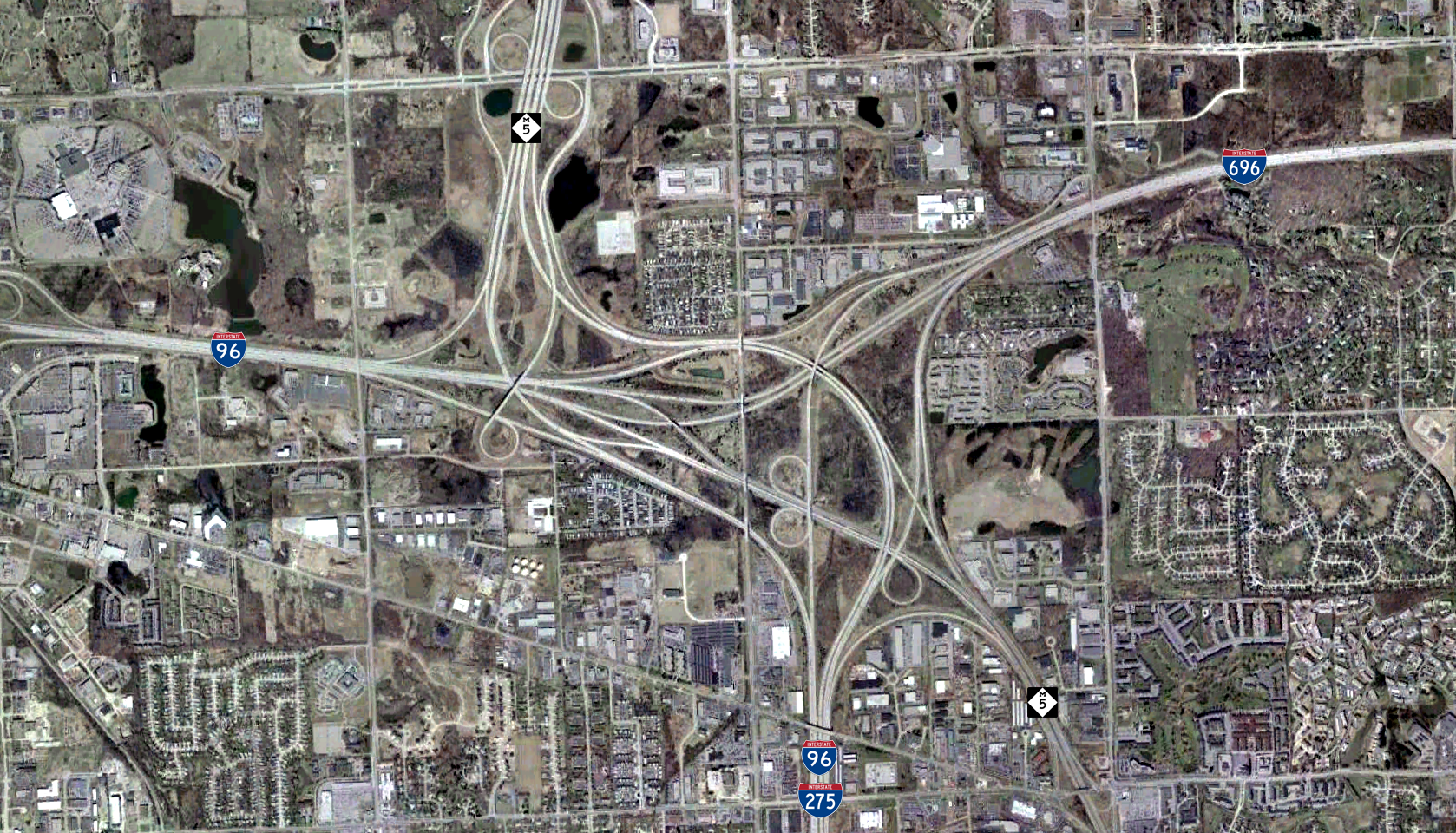
| Description | Satellite image of the interchange at the confluence of I-96, I-696, I-275 and M-5 near Novi, Michigan. |
| Date | 10 April – 4 May 2002 for base map, 6 February 2008 for annotations |
| Source | Satellite image USGS Orthophoto (dataset ID: 200204_detroit_mi_0x3000m_utm_clr) |
| Author | United States Geological Survey for base map, Stratosphere for annotations |
| Permission (Reusing this file) |
Public domain for base map and user-added annotations |
| Object location | | View this and other nearby images on: OpenStreetMap |
|---|
.png¶ms=042.483112_N_-083.439459_E_globe:Earth_class:object_type:object__&language=en)
This image is in the public domain in the United States because it only contains materials that originally came from the United States Geological Survey, an agency of the United States Department of the Interior. For more information, see the official USGS copyright policy.
|
File history
Click on a date/time to view the file as it appeared at that time.
| Date/Time | Thumbnail | Dimensions | User | Comment | |
|---|---|---|---|---|---|
| current | 19:04, 11 January 2017 | | 1,678 × 960 (2.53 MB) | Jeanjung212 | Lossless Compressed/optimized png decreasing file size by 158723 bytes |
| 09:57, 6 February 2008 |  | 1,678 × 960 (2.68 MB) | Stratosphere | {{Information |Description=Satellite Image of the Mixing Bowl interchange, the confluence of I-96, I-696, I-275 and M-5 near Novi, Michigan |Source=Satellite image USGS Orthophoto |Date=February 6, 2008 |Author= Stratosphere |Permiss |
File usage
The following pages on the English Wikipedia use this file (pages on other projects are not listed):
- Interstate 275 (Michigan)
- Interstate 696
- Interstate 96
- List of Interstate Highways in Michigan
- M-5 (Michigan highway)
- Road junction
- Roads and freeways in metropolitan Detroit
- Spaghetti junction
- Transportation in metropolitan Detroit
- Talk:Interchange (road)/Archive 1
- Wikipedia:Reference desk/Archives/Miscellaneous/2014 June 6
- Wikipedia:Wikipedia Signpost/2013-06-12/Featured content
- Wikipedia:Wikipedia Signpost/Single/2013-06-12
- Portal:Michigan highways/Pictures
- Portal:Michigan highways/Selected picture
- Portal:Michigan highways/Selected picture/9
Global file usage
The following other wikis use this file:
- Usage on de.wikipedia.org
- Usage on fr.wikipedia.org
.png)