File:Southern Levant map.svg

Page contents not supported in other languages.
This is a file from the Wikimedia Commons
From Wikipedia, the free encyclopedia

Original file(SVG file, nominally 524 × 524 pixels, file size: 418 KB)

Summary

Description
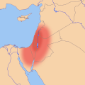
English: Location map of the en:Southern Levant, based on an approximate, geographic definition:
  • "The southern Levant, as defined here, is delimited by the Litani River to the north, the Jordan Rift Valley to the East, the Gulf of Aqaba to the south, and the Mediterranean Sea and Sinai Desert to the west."[1]
  • "The region defined as the Southern Levant encompasses the territory crossed by the valleys of the Litani and Jordan, including the Mediterranean littoral extending from Lebanon to northern Sinai. Moreover, the Negev, the Sinai peninsula and Jordan are considered parts of this vast region."[2]
  • "The southern Levant refers to all of the territory south of the headwaters of the Orontes River and west of the Syrian Desert"[3]

Legend

  Core area of the Southern Levant
  Other regions sometimes included in the Southern Levant

References

  1. Peregrine, Peter N. (2003) Encyclopedia of Prehistory: Volume 8: South and Southwest Asia, Springer Science & Business Media, pp. 86 ISBN: 9780306462627.
  2. Yakar, Jak (1998). "The socio-economic structure of prehistoric communities in the Southern Levant, ca. 13000-8000 BP". Documenta Praehistorica XXV.
  3. Routledge, Bruce (2004) Moab in the Iron Age: Hegemony, Polity, Archaeology, University of Pennsylvania Press, pp. 223 ISBN: 081223801X.
Date
Source Own work
Author Joe Roe

Licensing

I, the copyright holder of this work, hereby publish it under the following license:
w:en:Creative Commons
attribution share alike
This file is licensed under the Creative Commons Attribution-Share Alike 4.0 International license.
You are free:
  • to share – to copy, distribute and transmit the work
  • to remix – to adapt the work
Under the following conditions:
  • attribution – You must give appropriate credit, provide a link to the license, and indicate if changes were made. You may do so in any reasonable manner, but not in any way that suggests the licensor endorses you or your use.
  • share alike – If you remix, transform, or build upon the material, you must distribute your contributions under the same or compatible license as the original.

Captions

Add a one-line explanation of what this file represents

Items portrayed in this file

depicts

26 July 2016

File history

Click on a date/time to view the file as it appeared at that time.

Date/TimeThumbnailDimensionsUserComment
current14:32, 2 August 2016Thumbnail for version as of 14:32, 2 August 2016524 × 524 (418 KB)Joe RoeTweaked ranges per en:Talk:Southern Levant#Maps
21:05, 26 July 2016Thumbnail for version as of 21:05, 26 July 2016524 × 524 (416 KB)Joe RoeDifferentiated "core" and "inclusive" definitions
18:41, 26 July 2016Thumbnail for version as of 18:41, 26 July 2016524 × 524 (391 KB)Joe RoeUser created page with UploadWizard
The following pages on the English Wikipedia use this file (pages on other projects are not listed):

Global file usage

The following other wikis use this file:

Metadata