
File:South Puyallup River Bridge.jpg

Size of this preview: 800 × 548 pixels. Other resolutions: 320 × 219 pixels | 640 × 439 pixels | 1,024 × 702 pixels | 1,280 × 877 pixels | 2,560 × 1,754 pixels | 4,660 × 3,193 pixels.
Original file (4,660 × 3,193 pixels, file size: 2.29 MB, MIME type: image/jpeg)
| This is a file from the Wikimedia Commons. Information from its description page there is shown below. Commons is a freely licensed media file repository. You can help. |
Summary
|
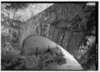
This is an image of a place or building that is listed on the National Register of Historic Places in the United States of America. Its reference number is 91000198. |
| Description |
The South Puyallup River Bridge — in Mount Rainier National Park, Pierce County, Washington.
|
|||||||||||||||||||||||
| Date | Summer 1992 | |||||||||||||||||||||||
| Source |
Library of Congress, Prints and Photograph Division, Historic American Engineering Record: HAER WASH,27-LONG.V,20-1
|
|||||||||||||||||||||||
| Author |
|
|||||||||||||||||||||||
| Permission (Reusing this file) |
|
|||||||||||||||||||||||
| Other versions | ||||||||||||||||||||||||

.jpg)
| Object location | | View this and other nearby images on: OpenStreetMap |
|---|
File history
Click on a date/time to view the file as it appeared at that time.
| Date/Time | Thumbnail | Dimensions | User | Comment | |
|---|---|---|---|---|---|
| current | 00:49, 28 March 2009 | | 4,660 × 3,193 (2.29 MB) | Martin H. | High res; cropped |
| 22:40, 20 March 2008 |  | 961 × 658 (458 KB) | Murderbike~commonswiki | {{Information |Description=The South Puyallup River Bridge in Mount Rainier National Park |Source=http://memory.loc.gov/cgi-bin/ampage?collId=hhphoto&fileName=wa/wa0300/wa0362/photos/browse.db&action=browse&recNum=0&title2=South%20Puyallup%20River%20Bridg |
File usage
The following pages on the English Wikipedia use this file (pages on other projects are not listed):
- List of bridges on the National Register of Historic Places in Washington (state)
- List of crossings of the Puyallup River
- National Register of Historic Places listings in Mount Rainier National Park
- National Register of Historic Places listings in Pierce County, Washington
- South Puyallup River Bridge
Global file usage
The following other wikis use this file:
- Usage on fr.wikipedia.org
- Usage on www.wikidata.org