
File:South Asia UN.png

Original file (2,960 × 3,588 pixels, file size: 1.63 MB, MIME type: image/png)
| This is a file from the Wikimedia Commons. Information from its description page there is shown below. Commons is a freely licensed media file repository. You can help. |
Summary
| Description |
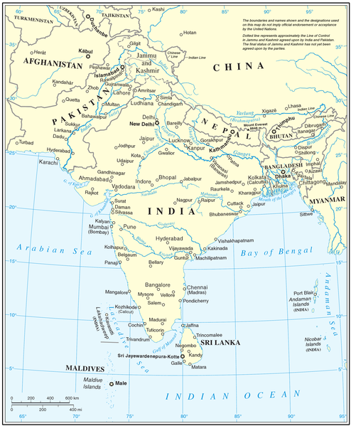
English: UN map of South Asia, cropped to remove UN map number. |
| Source | UN.org |
| Author | UN |
| This image is a map derived from a United Nations map.
Unless stated otherwise, UN maps are to be considered in the public domain. This applies worldwide. UN maps are, in principle, open source material and you can use them in your work or for making your own map. UN requests however that you delete the UN name, logo and reference number upon any modification to the map. Content of your map will be your responsibility. You can state in your publication, if you wish, something like: based on UN map … (map name, map number, revision number and date). See: Geospatial Information Section. And: Geospatial, location data for a better world. |
 |
File history
Click on a date/time to view the file as it appeared at that time.
| Date/Time | Thumbnail | Dimensions | User | Comment | |
|---|---|---|---|---|---|
| current | 18:51, 26 January 2009 | | 2,960 × 3,588 (1.63 MB) | AxelBoldt | {{Information |Description=UN map of South Asia, cropped to remove UN map number. |Source= http://www.un.org/Depts/Cartographic/map/profile/seasia.pdf |Date= |Author=UN |Permission= |other_versions= }} {{UN map}} Category:Maps of South Asia |
| 18:45, 26 January 2009 |  | 3,936 × 4,780 (2.26 MB) | AxelBoldt | {{Information |Description=UN map of South Asia, cropped to remove UN map number. |Source= http://www.un.org/Depts/Cartographic/map/profile/seasia.pdf |Date= |Author=UN |Permission= |other_versions= }} {{UN map}} Category:Maps of South Asia <!--{{Ima |
File usage
Global file usage
The following other wikis use this file:
- Usage on ar.wikipedia.org
- Usage on bh.wikipedia.org
- Usage on bn.wikipedia.org
- Usage on eo.wikipedia.org
- Usage on hi.wikipedia.org
- Usage on id.wikipedia.org
- Usage on ja.wikipedia.org
- Usage on ko.wikipedia.org
- Usage on lfn.wikipedia.org
- Usage on mdf.wikipedia.org
- Usage on nl.wikipedia.org
- Usage on pnb.wikipedia.org
- Usage on ru.wikipedia.org
- Usage on sd.wikipedia.org
- Usage on simple.wikipedia.org
- Usage on ta.wikipedia.org
- Usage on ur.wikipedia.org
- Usage on vi.wikipedia.org