
File:South America satellite plane Bacia do Parana.jpg
Size of this preview: 418 × 599 pixels. Other resolutions: 167 × 240 pixels | 422 × 605 pixels.
Original file (422 × 605 pixels, file size: 30 KB, MIME type: image/jpeg)
| This is a file from the Wikimedia Commons. Information from its description page there is shown below. Commons is a freely licensed media file repository. You can help. |
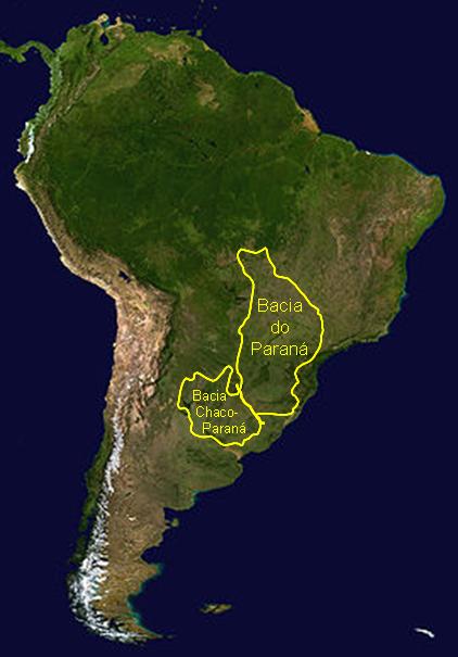
Summary
| Description |
English: Geographic limits of Paraná Basin, South America
Português: Limites geográficos da Bacia do Paraná, América do Sul |
| Date | |
| Source | Modified by GeoPotinga from Nasa original South America satellite plane.jpg in public domain |
| Author | GeoPotinga |
| Other versions | Derivative works of this file: South America satellite plane Bacia do Parana es.jpg |
Licensing
| I, the copyright holder of this work, release this work into the public domain. This applies worldwide. In some countries this may not be legally possible; if so: I grant anyone the right to use this work for any purpose, without any conditions, unless such conditions are required by law. |
File history
Click on a date/time to view the file as it appeared at that time.
| Date/Time | Thumbnail | Dimensions | User | Comment | |
|---|---|---|---|---|---|
| current | 13:28, 1 February 2009 | | 422 × 605 (30 KB) | GeoPotinga | {{Information |Description={{pt-br|1=Limites geográficos da Bacia Geológica do Paraná}} |Source=Modified by owner from Nasa original South America satellite plane.jpg in public domain |Author=GeoPotinga |Date=2008-02-01 |Permission= |
File usage
The following pages on the English Wikipedia use this file (pages on other projects are not listed):
Global file usage
The following other wikis use this file:
- Usage on de.wikipedia.org
- Usage on nl.wikipedia.org
- Usage on pt.wikipedia.org
- Usage on ru.wikipedia.org